WEPP (Water Erosion Prediction Project model)

The Water Erosion Prediction Project (WEPP) model is a process-based, distributed parameter, continuous simulation, erosion prediction model for use on personal computers.

Water ErosionPredictionprocess-baseddistributed parametercontinuous simulation

Contributor(s)

Initial contribute: 2019-12-29

Authorship

:  
USDA
:  
View
Is authorship not correct? Feed back

Classification(s)

Application-focused categoriesNatural-perspectiveLand regions

Detailed Description

English {{currentDetailLanguage}} English

Quoted from: https://www.ars.usda.gov/midwest-area/west-lafayette-in/national-soil-erosion-research/docs/wepp/wepp-model-documentation/ 

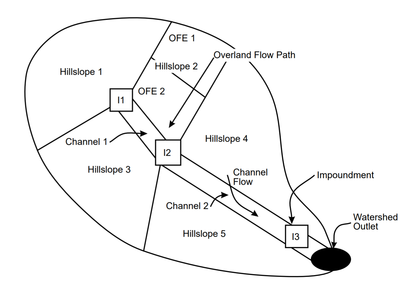
      The USDA - Water Erosion Prediction Project (WEPP) model represents a new erosion prediction technology based on fundamentals of stochastic weather generation, infiltration theory, hydrology, soil physics, plant science, hydraulics, and erosion mechanics. The hillslope or landscape profile application of the model provides major advantages over existing erosion prediction technology. The most notable advantages include capabilities for estimating spatial and temporal distributions of soil loss (net soil loss for an entire hillslope or for each point on a slope profile can be estimated on a daily, monthly, or average annual basis), and since the model is process-based it can be extrapolated to a broad range of conditions that may not be practical or economical to field test. In watershed applications, sediment yield from entire fields can be estimated. Figure 1.1.1 depicts a small watershed on which the WEPP erosion model could be applied.

Figure 1.1.1 Schematic of a small watershed which the WEPP erosion model could be applied to. Individual hillslopes (1 to 5), or the entire watershed (composed of 5 hillslopes, 2 channel segments, and 3 impoundments) could be simulated.


      Processes considered in hillslope profile model applications include rill and interrill erosion, sediment transport and deposition, infiltration, soil consolidation, residue and canopy effects on soil detachment and infiltration, surface sealing, rill hydraulics, surface runoff, plant growth, residue decomposition, percolation, evaporation, transpiration, snow melt, frozen soil effects on infiltration and erodibility, climate, tillage effects on soil properties, effects of soil random roughness, and contour effects including potential overtopping of contour ridges. The model accommodates the spatial and temporal variability in topography, surface roughness, soil properties, crops, and land use conditions on hillslopes.

     In watershed applications, the model allows linkage of hillslope profiles to channels and impoundments. Water and sediment from one or more hillslopes can be routed through a small fieldscale watershed. Almost all of the parameter updating for hillslopes is duplicated for channels. The model simulates channel detachment, sediment transport and deposition. Impoundments such as farm ponds, terraces, culverts, filter fences and check dams can be simulated to remove sediment from the flow.

模型元数据

{{htmlJSON.HowtoCite}}

WEEP team (2019). WEPP (Water Erosion Prediction Project model), Model Item, OpenGMS, https://geomodeling.njnu.edu.cn/modelItem/04843065-884a-4f59-ba8e-0f58b132d941
{{htmlJSON.Copy}}

History

Last modifier
zhangshuo
Last modify time
2021-01-06
Modify times
View History

Contributor(s)

Initial contribute : 2019-12-29

{{htmlJSON.CoContributor}}

Authorship

:  
USDA
:  
View
Is authorship not correct? Feed back

History

Last modifier
zhangshuo
Last modify time
2021-01-06
Modify times
View History

QR Code

×

{{curRelation.overview}}
{{curRelation.author.join('; ')}}
{{curRelation.journal}}


{{htmlJSON.RelatedItems}}

{{htmlJSON.LinkResourceFromRepositoryOrCreate}}{{htmlJSON.create}}.

Drop the file here, orclick to upload.
Select From My Space
+ add

{{htmlJSON.authorshipSubmitted}}

Cancel Submit
{{htmlJSON.Cancel}} {{htmlJSON.Submit}}
{{htmlJSON.Localizations}} + {{htmlJSON.Add}}
{{ item.label }} {{ item.value }}
{{htmlJSON.ModelName}}:
{{htmlJSON.Cancel}} {{htmlJSON.Submit}}
名称 别名 {{tag}} +
系列名 版本号 目的 修改内容 创建/修改日期 作者
摘要 详细描述
{{tag}} + 添加关键字
* 时间参考系
* 空间参考系类型 * 空间参考系名称

起始日期 终止日期 进展 开发者
* 是否开源 * 访问方式 * 使用方式 开源协议 * 传输方式 * 获取地址 * 发布日期 * 发布者


编号 目的 修改内容 创建/修改日期 作者


时间分辨率 时间尺度 时间步长 时间范围 空间维度 格网类型 空间分辨率 空间尺度 空间范围
{{tag}} +
* 类型
图例


* 名称 * 描述
示例描述 * 名称 * 类型 * 值/链接 上传


{{htmlJSON.Cancel}} {{htmlJSON.Submit}}
Title Author Date Journal Volume(Issue) Pages Links Doi Operation
{{htmlJSON.Cancel}} {{htmlJSON.Submit}}
{{htmlJSON.Add}} {{htmlJSON.Cancel}}

{{articleUploading.title}}

Authors:  {{articleUploading.authors[0]}}, {{articleUploading.authors[1]}}, {{articleUploading.authors[2]}}, et al.

Journal:   {{articleUploading.journal}}

Date:   {{articleUploading.date}}

Page range:   {{articleUploading.pageRange}}

Link:   {{articleUploading.link}}

DOI:   {{articleUploading.doi}}

Yes, this is it Cancel

The article {{articleUploading.title}} has been uploaded yet.

OK
{{htmlJSON.Cancel}} {{htmlJSON.Confirm}}
yxMx0t20LDKx