ANIMO

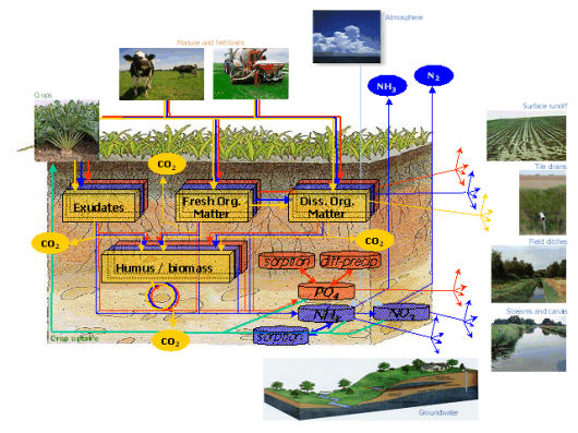
Animo is a detailed process-oriented simulation model for evaluation of nitrate leaching to groundwater, N- and P-loads on surface waters and greenhouse gas emission.

process-orientednitrate leachinggroundwatersurface watersgreenhouse gas emission

Contributor(s)

Initial contribute: 2019-10-22

Authorship

Is authorship not correct? Feed back

Classification(s)

Application-focused categoriesNatural-perspectiveLand regions

Detailed Description

English {{currentDetailLanguage}} English

Quoted from: https://www.wur.nl/en/Research-Results/Research-Institutes/Environmental-Research/Facilities-Tools/Software-models-and-databases/ANIMO.htm 

The model is primarily used for the ex-ante evaluation of fertilisation policy and legislation at regional and national scale. Animo aims to quantify the leaching of nutrients and the emission of greenhouse gasses as a function of fertilisation level, soil and water management and land use and  for a wide range of soil types and different hydrological conditions. The model comprises descriptions of the carbon, the nitrogen and the phosphorus cycle in both the unsaturated and the saturated part of the soil.

Animo is implemented in the STONE modelling framework and in the NL-Cat modelling framework.

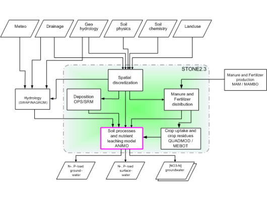
STONE comprises of a national scale soil and land use schematisation, results of a hydrological model and simulation modules for simulation of nitrogen deposition, for simulation of crop uptake and for simulation of fertiliser and manure distribution and for the simulation of nutrient dynamics in soils (Animo).

stone23.gif

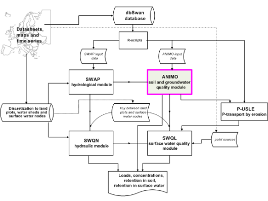
NL-Cat comprises of a set of models and scripts for the simulation of water flow and nutrient transport and transformations in both the soil and the surface waters at the catchment scale, in which the Animo model addresses the nutrient dynamics in the soil.  

EuroHarp.gif

模型元数据

{{htmlJSON.HowtoCite}}

Institute for Land and Water management Research (2019). ANIMO, Model Item, OpenGMS, https://geomodeling.njnu.edu.cn/modelItem/7cae73e4-bfd3-40a1-8f4b-999a69eea452
{{htmlJSON.Copy}}

History

Last modifier
zhangshuo
Last modify time
2021-01-11
Modify times
View History

Contributor(s)

Initial contribute : 2019-10-22

{{htmlJSON.CoContributor}}

Authorship

Is authorship not correct? Feed back

History

Last modifier
zhangshuo
Last modify time
2021-01-11
Modify times
View History

QR Code

×

{{curRelation.overview}}
{{curRelation.author.join('; ')}}
{{curRelation.journal}}


{{htmlJSON.RelatedItems}}

{{htmlJSON.LinkResourceFromRepositoryOrCreate}}{{htmlJSON.create}}.

Drop the file here, orclick to upload.
Select From My Space
+ add

{{htmlJSON.authorshipSubmitted}}

Cancel Submit
{{htmlJSON.Cancel}} {{htmlJSON.Submit}}
{{htmlJSON.Localizations}} + {{htmlJSON.Add}}
{{ item.label }} {{ item.value }}
{{htmlJSON.ModelName}}:
{{htmlJSON.Cancel}} {{htmlJSON.Submit}}
名称 别名 {{tag}} +
系列名 版本号 目的 修改内容 创建/修改日期 作者
摘要 详细描述
{{tag}} + 添加关键字
* 时间参考系
* 空间参考系类型 * 空间参考系名称

起始日期 终止日期 进展 开发者
* 是否开源 * 访问方式 * 使用方式 开源协议 * 传输方式 * 获取地址 * 发布日期 * 发布者


编号 目的 修改内容 创建/修改日期 作者


时间分辨率 时间尺度 时间步长 时间范围 空间维度 格网类型 空间分辨率 空间尺度 空间范围
{{tag}} +
* 类型
图例


* 名称 * 描述
示例描述 * 名称 * 类型 * 值/链接 上传


{{htmlJSON.Cancel}} {{htmlJSON.Submit}}
Title Author Date Journal Volume(Issue) Pages Links Doi Operation
{{htmlJSON.Cancel}} {{htmlJSON.Submit}}
{{htmlJSON.Add}} {{htmlJSON.Cancel}}

{{articleUploading.title}}

Authors:  {{articleUploading.authors[0]}}, {{articleUploading.authors[1]}}, {{articleUploading.authors[2]}}, et al.

Journal:   {{articleUploading.journal}}

Date:   {{articleUploading.date}}

Page range:   {{articleUploading.pageRange}}

Link:   {{articleUploading.link}}

DOI:   {{articleUploading.doi}}

Yes, this is it Cancel

The article {{articleUploading.title}} has been uploaded yet.

OK
{{htmlJSON.Cancel}} {{htmlJSON.Confirm}}
6T.r0BAdGFFD