ARNO model

The ARNO model is a semi-distributed conceptual rainfall-runoff model, which is now in widespread use both in land-surface-atmosphere process research and as an operational flood forecasting tool on several catchments in different parts of the world. The model, which derives its name from its first application to the Arno River, incorporates the concepts of a spatial probability distribution of soil moisture capacity and of dynamically varying saturated contributing areas.

conceptualrainfall-runoff

Contributor(s)

Initial contribute: 2019-12-28

Authorship

:  
意大利波罗尼亚大学
Is authorship not correct? Feed back

Classification(s)

Application-focused categoriesNatural-perspectiveLand regions

Detailed Description

English {{currentDetailLanguage}} English

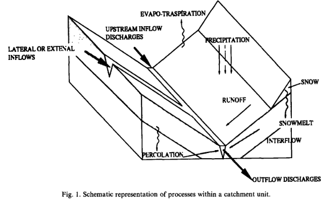
The ARNO model is a semi-distributed conceptual model in integral form, which is based on the schematic representation of catchment hydrology shown in Fig. 1.

The main physical phenomena represented in the ARNO model are the following (Fig. 1): water balance in the soil, on the basis of present soil moisture content, rainfall, runoff, evapotranspiration, drainage and percolation; water losses through evapotranspiration, evaluated on the basis of the air temperature data and the soil moisture content; snow accumulation and/or melt, based upon the energy balance of the snow cover (when present) as a function of the air temperature and precipitation data; groundwater flow represented by means of a multiple linear reservoir-type model; overland and channel flow routing represented with linear parabolic models.

The ARNO model is characterized by two main components: the first and most important component represents the soil moisture balance, and the second describes the transfer of runoff to the outlet of the basin. The relevance of the soil component emerges from the highly nonlinear mechanism with which the soil moisture content and its distribution controls the dynamically varying size of the saturated areas mainly responsible for a direct conversion of rainfall into runoff. The second component describes the way in which runoff is routed and transferred along the hillslopes to the drainage channels and along the channel network to the outlet of the basin.

[1] E. Todini, The ARNO Rainfall-Runoff Model, Journal of Hydrology, Vol. 175, No. 1-4, 1996, pp. 339-382. doi:10.1016/S0022-1694(96)80016-3

模型元数据

{{htmlJSON.HowtoCite}}

{{htmlJSON.Copy}}

Contributor(s)

Initial contribute : 2019-12-28

{{htmlJSON.CoContributor}}

Authorship

:  
意大利波罗尼亚大学
Is authorship not correct? Feed back

QR Code

×

{{curRelation.overview}}
{{curRelation.author.join('; ')}}
{{curRelation.journal}}


{{htmlJSON.RelatedItems}}

{{htmlJSON.LinkResourceFromRepositoryOrCreate}}{{htmlJSON.create}}.

Drop the file here, orclick to upload.
Select From My Space
+ add

{{htmlJSON.authorshipSubmitted}}

Cancel Submit
{{htmlJSON.Cancel}} {{htmlJSON.Submit}}
{{htmlJSON.Localizations}} + {{htmlJSON.Add}}
{{ item.label }} {{ item.value }}
{{htmlJSON.ModelName}}:
{{htmlJSON.Cancel}} {{htmlJSON.Submit}}
名称 别名 {{tag}} +
系列名 版本号 目的 修改内容 创建/修改日期 作者
摘要 详细描述
{{tag}} + 添加关键字
* 时间参考系
* 空间参考系类型 * 空间参考系名称

起始日期 终止日期 进展 开发者
* 是否开源 * 访问方式 * 使用方式 开源协议 * 传输方式 * 获取地址 * 发布日期 * 发布者


编号 目的 修改内容 创建/修改日期 作者


时间分辨率 时间尺度 时间步长 时间范围 空间维度 格网类型 空间分辨率 空间尺度 空间范围
{{tag}} +
* 类型
图例


* 名称 * 描述
示例描述 * 名称 * 类型 * 值/链接 上传


{{htmlJSON.Cancel}} {{htmlJSON.Submit}}
Title Author Date Journal Volume(Issue) Pages Links Doi Operation
{{htmlJSON.Cancel}} {{htmlJSON.Submit}}
{{htmlJSON.Add}} {{htmlJSON.Cancel}}

{{articleUploading.title}}

Authors:  {{articleUploading.authors[0]}}, {{articleUploading.authors[1]}}, {{articleUploading.authors[2]}}, et al.

Journal:   {{articleUploading.journal}}

Date:   {{articleUploading.date}}

Page range:   {{articleUploading.pageRange}}

Link:   {{articleUploading.link}}

DOI:   {{articleUploading.doi}}

Yes, this is it Cancel

The article {{articleUploading.title}} has been uploaded yet.

OK
{{htmlJSON.Cancel}} {{htmlJSON.Confirm}}
JK7hJAcr18Df