Quoted from: http://www1.ete.inrs.ca/activites/modeles/cequeau/ainformation.htm#Introduction
- Considering the increasing use of water resources, hydrological forecasting is one of the most important item of applied hydrology. Forecasting is used for flood control, stream regulation, hydroelectric production, dimensioning hydraulic works, and pollution control.
Hydrologists developed tools, called hydrological models, to answer these needs in a satisfactory manner. Such models have very rapidly evolved in the last few decades with the advent of increasingly powerful computers.
CEQUEAU hydrological model, developed at the INRS-eau since 1971, is a water balance, distributed parametric model.
CEQUEAU hydrological model
CEQUEAU hydrological model is a user friendly distributed deterministic model that takes into account the physical characteristics of a watershed as well as their space domain variations This operation is made possible through a subdivision of the watershed in two (2) discretisations.
Schematic representation of the watershed
The first discretization of the watershed is a set of sqare areas with identical dimensions called "whole square". The dimension of a "whole square" depends mainly on the size of the watershed investigated, the available meteorological data, the topography, etc .. . The physiographic data required for each "whole square" are: altitude, respective aerial percentage of forests, lakes and marshes. This data set is obtained from the topographic maps of the watershed under study or else with the help of GIS. The present dimensions of the model allow a maximum of 1000 "whole squares".
The second discretisation consists of a subdivision of the "whole squares" into "partial squares". These last squares result from a subdivision of the "whole squares" as a function of the water divides. As many as four (4) "partial squares" may be encountered in a "whole square". Data required for each "partial square" are: direction of water flow and its aerial percentage with respect to the subdivided "whole square". The actual dimensions of the model allow a maximum of 2500 "partial squares".
These two (2) subdivisions allow:
• the use of data coming from infra-red and radar imagery;
• the use of forecast meteorological data at some or all points of a grid;
• to follow the formation and evolution of streamflow in space and time;
• taking into account any artificial modifications of the watershed (existing or virtual dams,
deviations, water intakes, etc ..);
• simulation the streamflows at any point of the drainage network.
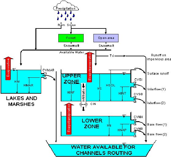
The hydrological model comprises two (2) main parts, the objectives of which are an improved description of the eventual water flow towards the exit of the watershed. The first part deals with the vertical flow, the principal related phenomena being: rain, snow melt, evapo-transpiration, infiltration and variations of near-surface and deeper water reserves. This first part is labelled: "production function" and is calculated on each "whole square" and for each temporal step. The second part deals with water flow transfer in the drainage network. The processes included in this second part take into account the influence of lakes, marshes, artificial waterworks such as dams, deviations, canals, etc .. This part is labelled "transfer function" and it requires the use of "partial squares".
Production function
The hydrological water-balance is carried out on each "whole square" and at each temporal step (the model gives the possibilities to simulate with time steps of 1, , 3, 4, 6, 8, 12 or 24 hours) with the help of the production function. The goal of this function is a faithful representation, in a simple and realistic fashion of the different trajectories taken by atmospheric waters between the time it falls on the soil surface and the moment it reaches the river. The origin of incoming atmospheric water within the watershed is either rain or snow. Water originating from rain is in practice, immediately available for transformation operations leading to flow rates. For snow, it is necessary to define a snow melt model.
Whatever the origin of atmospheric waters falling on the soil, their availability for water flow towards the exit of the watershed are submitted to different processes which shall have a direct influence on the formation of the streamflow.
These processes are represented schematically in CEQUEAU model by a, series of interconnected reservoirs. Mathematical relations are used to calculate the different mass transfers based on the temporal step used for the simulation.
 Production function of CEQUEAU model
The objective of these mathematical relations is a realistic reproduction of the various components of the hydrological balance which are the following:
- formation and snow melt of the snowpack;
- evaporation and evapotranspiration;
- water content in the unsaturated zone (SOIL);
- water content in the saturated zone (WATER TABLE);
- water content in LAKES and MARSHES.
Transfer function
The production function described previously results in a water volume on each "whole square" which is available for the transfer to the river, without having to know its exact origin (direct or delayed run-off, draining of the WATER TABLE or LAKES and MARSHES). This transfer is carried from one "partial square" to the next.
The water volume available in a "partial square" is obtained by multiplying the volume produced on each "whole square" by the percentage of area occupied by the "partial square" considered. This volume is added to volumes entering this element from the "partial square(s)" located directly upstream. The resulting water volume becomes the volume available for the transfer towards the element situated immediately downstream. This process is repeated from one element to the next up to the exit of the watershed.
The following illustrations show the diagram of the transfer function.

A) Flow directions on the horizontal B) Downstream routing
Transfer function of CEQUEAU model
On illustration B) for instance, the "partial square" A of the "whole square"[2] receives QB1 portion of the water flow from portion B of the upstream "whole square" [1]; its production is added before letting the water of portion QA2 flow to the "partial square" A of downstream element [3]. The volume of water flow from one element to the next, for a specific temporal step, depends on the water available in the reserves and the physical characteristics of the river on the "partial square" considered. CEQUEAU model calculates this volume with the aid of a transfer coefficient characteristic of each "partial square" and of the quantity of water available on each of these elements.
Physiographic data required
The data required for each "whole square" are:
• altitude;
• percentage of forested area;
• percentage of lakes;
• percentage of marshes;
This data set is determined from the topographic maps of the watershed investigated or else with GIS.
The data required for each "partial square" are:
• the direction of water flow;
• its relative aerial percentage with respect to the "whole square".
These data are obtained from the topographic maps of the watershed.
Temporal data required
For simulation:
• maximum and minimum air temperatures at the meteorological stations
• liquid and solid precipitation at the meteorological stations
• snow depth surveys (optional)
• observed streamflow for the calibration period.
For short term forecasting:
• forecasting of air temperatures at the meteorological stations or at some points of a grid or
means on the watershed;
•forecasting of liquid and solid precipitation at the meteorological stations or at some points of a
grid or means on the watershed;
For mid-term forecasting:
• meteorological data (air temperature and precipitation) historical means on the watershed.
CEQUEAU environment
The Windows version of CEQUEAU makes use of a user friendly interface. The information required for the simulations (physiographic and hydro-meteorological data as well as all the parameters related to simulations) is organisated as projects which may be saved on disk. Each project makes reference to one or many watersheds and may include many trials of simulation. This concept allows an easy management of the input data for the model as well as the possibility for the user to save the simulation results.
Have a look at CEQUEAU interface
The three (3) first figures below show some of the windows produced with the CEQUEAU interface for the management of a project and for the presentation of graph.
All data files used for the model may be created or edited with the help of the CEQUEAU editor. This editor is conceived in such away as to insure the conformity of the format of the data with the one required by the programs used for CEQUEAU. For each of the vector fields, the editor verifies the conformity of the format and of the value. The editor provides equally as a comment the description of the vectors or the fields. The last three (3) figures below show the files of physiographic data (*.PHY), of the hydro-meteorological data (*.DHM) and of the parameters of the model ((*.PAH) opened with CEQUEAU editor.
- (Please click on one figure or its legend to obtain a blown up version)
Simulation results
Simulation results are saved on different files and may be analysed with thehelp of different types of graphs created with CEQUEAU interface. Three (3) types of graphs are available: graphs for spatial data, graphs for temporal data, and graphs for forecast data.
Graphs for spatial data
Graphs for saptial data allow the spatial representation of various data calculated for each "whole square". The data currently available are:
- references to "whole squares";
- mean elevation of "whole squares";
- percentage of forested area on "whole squares";
- percentage of lakes and marches on "whole squares";
- daily rain;
- mean daily temperature;
- snow accumulation on the soil;
- mean daily snowmelt;
- daily evaporation;
- water level in the SOIL reservoir;
- water level in the WATER TABLE reservoir;
Examples:
(Please click on one figure or its legend to obtain a blown up version)
Graphs of temporal data
- The temporal graphs show the temporal evolution of various observed and calculated data by the model with various styles. The illustration style used for the data presentation is selected in the Option window for the graph required. The data currently available are:
- streamflows/levels;
- meteorological data;
- other temporal data;
- data for quality.
Examples:
(Please click on one figure or its legend to obtain a blown up version)
Graphs of forcast data
Four (4) types of graphs show the forcast data:
• Forecast streamflow for a specific date;
•forecast streamflow for a specific period;
This graph may be undertaken for forecasting step 1 till the number of forecast
steps selected. This graph may be used to verify forecasting previously undertaken.
•mid-term streamflow forecast;
This graph allows the determination of streamflow forecast at a specific frequency.
• streamflow forecast with manual updating.
This graph allows also visualizing and modifying if necessary, the meteorological data
and states variables, so that the days previous the forecasting, the observed and
simulated streamflows are comparable.
Examples:
(Please click on one figure or its legend to obtain a blown up version)
Setting required
- Computer:
- PC 486 or Pentium
- Memory size:
- 16 Meg RAM
- Disk space:
- 10 Meg
- Exploitation systems:
- Windows 3.1, Windows 95/98 or Windows NT


