TAUDEM - Stream Reach And Watershed

The Stream Network Analysis toolset contains tools for creating and analyzing stream networks.

TAUDEMTERRAIN ANALYSISSTREAM NETWORK ANALYSIS

Contributor(s)

Initial contribute: 2020-12-16

Authorship

:  
UtahState University
:  
david.tarboton@usu.edu
:  
View
Is authorship not correct? Feed back

Classification(s)

Method-focused categoriesData-perspectiveGeoinformation analysis

Detailed Description

English {{currentDetailLanguage}} English

Quoted From : https://hydrology.usu.edu/taudem/taudem5/help53/StreamReachAndWatershed.html

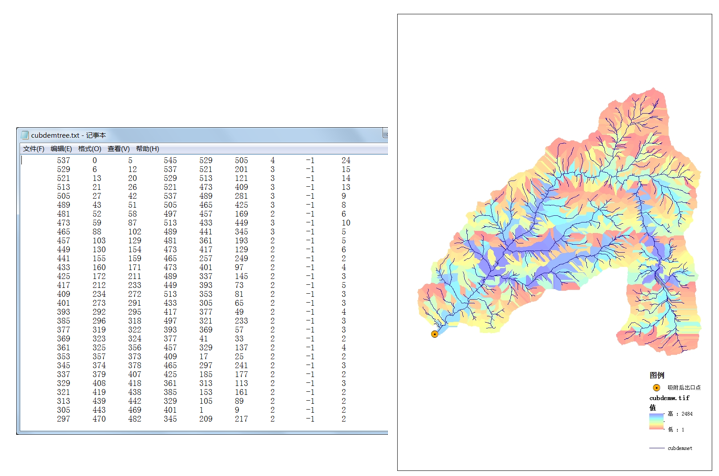
    This tool produces a vector network and OGR file from the stream raster grid. The flow direction grid is used to connect flow paths along the stream raster. The Strahler order of each stream segment is computed. The subwatershed draining to each stream segment (reach) is also delineated and labeled with the value identifier that corresponds to the WSNO (watershed number) attribute in the Stream Reach OGR file.

    This tool orders the stream network according to the Strahler ordering system. Streams that don't have any other streams draining in to them are order 1. When two stream reaches of different order join the order of the downstream reach is the order of the highest incoming reach. When two reaches of equal order join the downstream reach order is increased by 1. When more than two reaches join the downstream reach order is calculated as the maximum of the highest incoming reach order or the second highest incoming reach order + 1. This generalizes the common definition to cases where more than two reaches join at a point. The network topological connectivity is stored in the Stream Network Tree file, and coordinates and attributes from each grid cell along the network are stored in the Network Coordinates file.

    The stream raster grid is used as the source for the stream network, and the flow direction grid is used to trace connections within the stream network. Elevations and contributing area are used to determine the elevation and contributing area attributes in the network coordinate file. Points in the outlets file are used to logically split stream reaches to facilitate representing watersheds upstream and downstream of monitoring points. The program uses the attribute field "id" in the outlets file as identifiers in the Network Tree file. This tool then translates the text file vector network representation in the Network Tree and Coordinates files into a polyline OGR file. Further attributes are also evaluated. The program has an option to delineate a single watershed by representing the entire area draining to the Stream Network as a single value in the output watershed grid.

模型元数据

{{htmlJSON.HowtoCite}}

David Tarboton (2020). TAUDEM - Stream Reach And Watershed, Model Item, OpenGMS, https://geomodeling.njnu.edu.cn/modelItem/df30a9c2-73d9-482b-a1d4-b0cae0d6f8ea
{{htmlJSON.Copy}}

Contributor(s)

Initial contribute : 2020-12-16

{{htmlJSON.CoContributor}}

Authorship

:  
UtahState University
:  
david.tarboton@usu.edu
:  
View
Is authorship not correct? Feed back

History

Last modifier
XiaoYu He
Last modify time
2021-02-24
Modify times
View History

QR Code

×

{{curRelation.overview}}
{{curRelation.author.join('; ')}}
{{curRelation.journal}}


{{htmlJSON.RelatedItems}}

{{htmlJSON.LinkResourceFromRepositoryOrCreate}}{{htmlJSON.create}}.

Drop the file here, orclick to upload.
Select From My Space
+ add

{{htmlJSON.authorshipSubmitted}}

Cancel Submit
{{htmlJSON.Cancel}} {{htmlJSON.Submit}}
{{htmlJSON.Localizations}} + {{htmlJSON.Add}}
{{ item.label }} {{ item.value }}
{{htmlJSON.ModelName}}:
{{htmlJSON.Cancel}} {{htmlJSON.Submit}}
名称 别名 {{tag}} +
系列名 版本号 目的 修改内容 创建/修改日期 作者
摘要 详细描述
{{tag}} + 添加关键字
* 时间参考系
* 空间参考系类型 * 空间参考系名称

起始日期 终止日期 进展 开发者
* 是否开源 * 访问方式 * 使用方式 开源协议 * 传输方式 * 获取地址 * 发布日期 * 发布者


编号 目的 修改内容 创建/修改日期 作者


时间分辨率 时间尺度 时间步长 时间范围 空间维度 格网类型 空间分辨率 空间尺度 空间范围
{{tag}} +
* 类型
图例


* 名称 * 描述
示例描述 * 名称 * 类型 * 值/链接 上传


{{htmlJSON.Cancel}} {{htmlJSON.Submit}}
Title Author Date Journal Volume(Issue) Pages Links Doi Operation
{{htmlJSON.Cancel}} {{htmlJSON.Submit}}
{{htmlJSON.Add}} {{htmlJSON.Cancel}}

{{articleUploading.title}}

Authors:  {{articleUploading.authors[0]}}, {{articleUploading.authors[1]}}, {{articleUploading.authors[2]}}, et al.

Journal:   {{articleUploading.journal}}

Date:   {{articleUploading.date}}

Page range:   {{articleUploading.pageRange}}

Link:   {{articleUploading.link}}

DOI:   {{articleUploading.doi}}

Yes, this is it Cancel

The article {{articleUploading.title}} has been uploaded yet.

OK
{{htmlJSON.Cancel}} {{htmlJSON.Confirm}}
vQcLJpoZuTgB