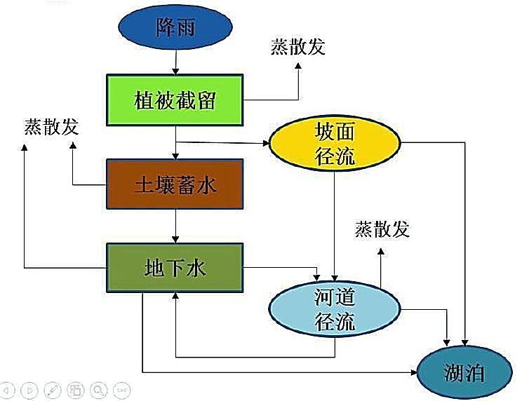
WATLAC模型,是中国科学院南京地理与湖泊研究所自主开发的一个针对湖泊集水域的地表——地下径流耦合模拟的分布式水文模型。模型利用研宄区的气象条件、土地利用类型、土壤类型、叶面积指数等数据,结合土地利用类型参数、土壤参数、河道属性及地下水等参数,模拟在日降水和蒸发条件下,流域地表、地下径流和土壤含水量的变化。具体过程包括植被栏截、土壤蓄水、地表径流、壤中流、土壤对地下水的补给、饱和地下水运动。WATLAC水文模型主要对湖泊流域水文过程与湖泊水量变化进行模拟,包括流域水文过程及分布式水文模拟研究;湖区降雨和蒸散发时空变化及湖区水量平衡研究;湖泊流域水文过程和湖泊水量对气候变化和人类活动响应的模拟预测研究。


The model can be invoked online: http://106.14.78.235:8060/modelser/preparation/5e0e06ea2b059a0eb02eade6
Reference
[1] Zhang Q, Li L. Development and application of an integrated surface runoff and groundwater flow model for a catchment of Lake Taihu watershed, China[J]. Quaternary International, 2009, 208(1-2): 102-108.
[2] Zhang Q, Werner A D. Integrated surface–subsurface modeling of Fuxianhu Lake catchment, Southwest China[J]. Water resources management, 2009, 23(11): 2189-2204.
[3] Ye X, Zhang Q, Bai L, et al. A modeling study of catchment discharge to Poyang Lake under future climate in China[J]. Quaternary International, 2011, 244(2): 221-229.
[4] Ye X, Liu J, Zhang Q. A modeling study of hydrological response to landuse changes based on hypothetical scenarios for the Poyang lake catchment[C]//2011 International Symposium on Water Resource and Environmental Protection. IEEE, 2011, 1: 550-553.
[5] Li X H, Zhang Q, Xu C Y. Suitability of the TRMM satellite rainfalls in driving a distributed hydrological model for water balance computations in Xinjiang catchment, Poyang lake basin[J]. Journal of Hydrology, 2012, 426: 28-38.
[6] Li Y, Zhang Q, Yao J, et al. Hydrodynamic and hydrological modeling of the Poyang Lake catchment system in China[J]. Journal of Hydrologic Engineering, 2013, 19(3): 607-616.