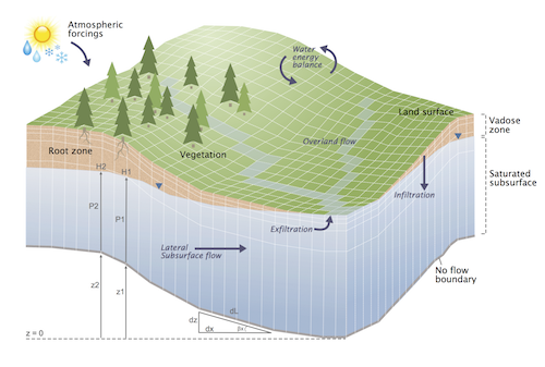
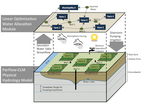
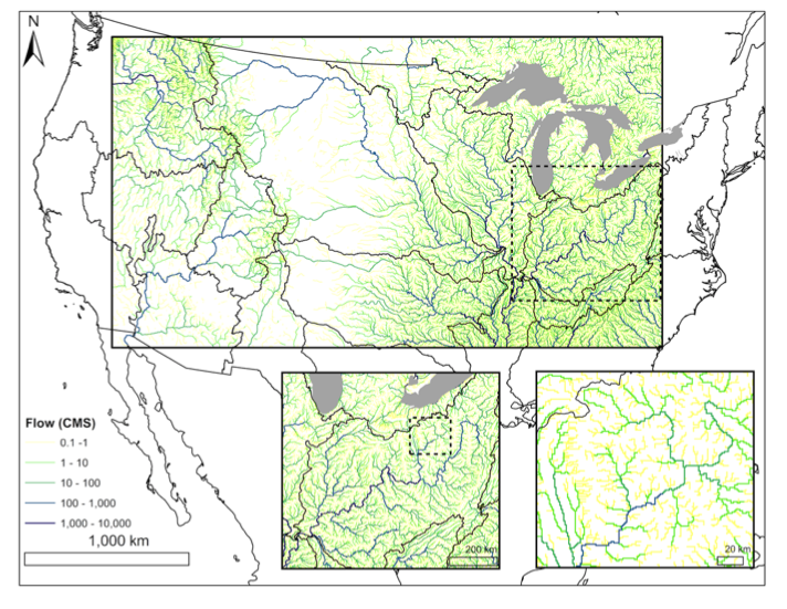
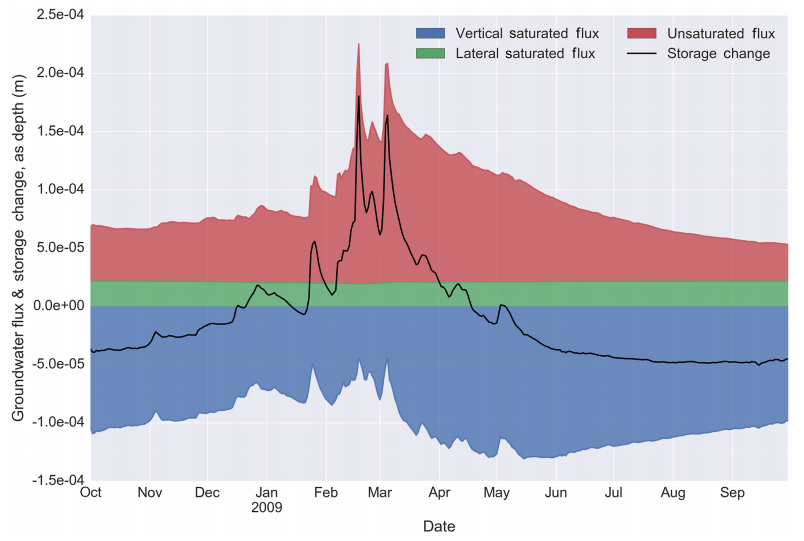
ParFlow

ParFlow is a numerical model that simulates the hydrologic cycle from the bedrock to the top of the plant canopy. It integrates three-dimensional groundwater flow with overland flow and plant processes using physically-based equations to rigorously simulate fluxes of water and energy in complex real-world systems.

numericalhydrologic cyclebedrockplant canopythree-dimensionalgroundwater flowoverland flowplant processes

Contributor(s)

Initial contribute: 2020-01-03

Authorship

:  
View
Is authorship not correct? Feed back

Classification(s)

Application-focused categoriesNatural-perspectiveLand regions

Detailed Description

English {{currentDetailLanguage}} English

Quoted from: https://parflow.org/#about 

ParFlow is a numerical model that simulates the hydrologic cycle from the bedrock to the top of the plant canopy. It integrates three-dimensional groundwater flow with overland flow and plant processes using physically-based equations to rigorously simulate fluxes of water and energy in complex real-world systems. ParFlow is a computationally advanced model that can run on laptops and supercomputers and has been used in hundreds of studies evaluating hydrologic processes from the hillslope to the continental scale. Our code is open source and we promote a community of active users and developers interested in advancing computational hydrology and improving hydrologic understanding. Details about the model, example applications and links for downloading and getting started with the code are provided below.

ParFlow is used extensively for water cycle research in idealized and real domains as part of process studies, forecasting analysis, data assimilation frameworks, hind-casting tools and climate change projections. The model has been extensively benchmarked and has more than 90 publications describing its development and application to diverse systems around the world. ParFlow applications have been built for the continental US (CONUS) and Continental Europe in addition to more than a dozen watersheds around the world including the Big Thompson, CO; Klamath, OR; Little Washita, OK; San Joaquin, CA; Sante Fe, FL; Chesapeake, MD; Rur as well as several headwater catchments, Germany.

ParFlow is a parallel, integrated hydrology model that simulates spatially distributed surface and subsurface flow, as well as land surface processes including evapotranspiration and snow. It solves saturated and variably saturated flow in three dimensions using either an orthogonal or terrain-following, semi-structured mesh that enables fine vertical resolution near the land surface and deep (~1 km) confined and unconfined aquifers. ParFlow models dynamic surface and subsurface flow solving the simplified shallow water equations implicitly coupled to Richards’ equation; this allows for dynamic two-way groundwater surface water interactions and intermittency in streamflow. The model uses robust linear and nonlinear solution techniques and exhibits efficient parallel scaling to large processor counts, more than 100K cores, enabling very large extent simulations with fine spatial resolution. ParFlow has been coupled to various land surface and atmospheric models such as CLMWRF, and TerrSysMP.

Features


  • Richards' equation for variably saturated 3D subsurface flow
  • Shallow water equations for surface flow
  • Modular, coupled land model that represents full energy budget, vegetative and snow processes
  • Robust nonlinear solvers (using the Kinsol Newton-Krylov package) and efficient multigrid linear solver (using the Hypre package)
  • Parallel implementation using multiple approaches and architectures
  • Excellent parallel scalability with production runs of more than 30k processors
  • Support for OpenMP and CUDA for use on accelerator architectures such as GPUs
  • Data formats such as SILO and NetCDF4
  • Implementation on different architectures and operating systems from "Laptop to Supercomputer" (single CPU, Linux clusters, highly scalable systems such as IBM Blue Gene) with the same source code and input on all platforms
  • Widespread use on many institutional computer systems including many of the fastest supercomputers in the world (e.g. Edison, Cori, Yellowstone, JUQUEEN)
  • Application to a wide range of hydrology problems and basins from small headwaters catchment to the continent
  • Broad community development and use
  • Extensive automated testing framework that follows best software practices
  • Implementation as a Docker instance for easy and efficient deployments
  • Large set of utilities for pre- and postprocessing and diagnistics calculations
  • Flexible and portable cmake built environment
ParFlow system schematic


Under development


  • Lagrangian particle tracking to simulate water residence time, surface subsurface exchange and contaminant transport
  • Adaptive mesh refinement unsing p4est
  • Extreme scaling capability up to more than 400k processors
  • Geochemical reactive transport with higher order advection schemes and reaction kinetics using CRUNCH
  • NetCDF CF meta-data convention for portability, provenance and worflow integration
  • In-situ visualisation and processing using VisIt
  • JUBE provenance-enabled work flow engine implementation for efficient development, benchmarking and run-control
  • Integrated water management including pumping, irrigation and diversions
ParFlow water management


Some example applications

ParFlow has been widely used to simulate flow and transport systems worldwide; here we highlight some recent examples linked to their corresponding publications. (Clicking on the figures opens a link to the publication's website.)

CONUS streamflow

Transient, integrated simulation of groundwater and surface water over the Continental US A representation of pre-development groundwater, surface water, and surface energy processes, which are driven by hourly forcing by NLDAS-II from the 1985 water year. At 1km lateral resolution, with 12TB of model output and 3TB of input, this is the first large-scale, high resolution simulation of its kind, capable of resolving complex interactions between climate, water and topography.


CV WTD

Groundwater-surface water interactions in the San Joaquin River Basin As one of the most productive agricultural regions of the United States and a major water resource for a growing population, the San Joaquin River basin in the Central Valley in California, is a case study in the water-food-energy nexus and sensitivity to a changing climate. Here, we seek to better understand the physical hydrology of the basin by simulating groundwater-surface water dynamics with ParFlow-CLM. Results suggest that mountain block hydraulic conductivity could account for 7-23% of total recharge in the Central Valley, an important finding for water resource management in California.


CORDEX WTD

Groundwater-land surface-atmosphere feedbacks during the European 2003 heat wave By coupling ParFlow to land and meteorological models, the fully coupled water cycle from groundwater to atmosphere can be simulated, a novel exploration in that atmospheric models rarely incorporate a dynamic water table and three dimensional subsurface flow. This study couples ParFlow to the meteorological model over Europe during the 2003 heat wave in order to investigate the effects of various lower boundary conditions and configurations on land-atmosphere moisture exchange and thermal energy.


CONUS residence times

Continental water residence times Ever wonder how long water spends in the subsurface? Residence time and groundwater age are vital to ecosystem development and human consumption, but measuring residence time distributions is difficult at large scales. ParFlow may be used to estimate water residence time when used in conjunction with a Lagrangian particle tracking approach. A simulation of groundwater age across the continental United States allows unique insight into the relationship between geography, climate, and water residence time in major basins.


Big Thompson MPB

The effects of insect-induced tree mortality on water and energy in mountain headwaters The mountain pine beetle (MPB) has decimated the high elevation lodgepole and ponderosa pine forests of Western United States and Canada over the past two decades. ParFlow-CLM was used to diagnose feedbacks that land disturbance at this scale has on water and energy fluxes in the Big Thompson watershed in Colorado. Results show that insect-induced reductions in canopy interception, transpiration, and snow pack are largely mitigated by heightened ground evaporation and ablation, adding to the growing number of studies citing damping of MPB hydrologic signal at large scales.


Wustebach

Scale dependent parameterization in integrated hydrologic modeling The highly instrumented Wüstebach catchment in Germany allows the unique opportunity to explore the application of the information entropy concept in subsurface parameterization of three dimensional hydrological models. Results suggest that amplifying soil hydraulic conductivity in regions where aggregation of observations at model scale leads to loss of topographic information content may increase model performance, an important finding for high-resolution, large-scale physically based modeling that requires detailed subsurface parameterization.


Wustebach

Moisture dependent irrigation and its feedbacks with integrated hydrology In this example, ParFlow was used in conjunction with a novel linear optimization water allocation module to evaluate the impact of groundwater-surface water interactions on moisture dependent irrigation in the Little Washita River Basin, Oklahoma.


AMMA Catch

Modeling the Critical Zone in an ephemeral West-African Monsoon system West-African hydrosystems are driven by seasonal monsoon dynamics with high variability. While the extreme drought in the 70's and 80's was surprisingly associated with runoff and water table recharge increase and (due to simultaneous land use change) in the Sahel, consequences in the southern, more humid Sudanian zone were a major drop in streamflow. Streamflow generation processes in this area involve subsurface processes (as opposed to Hortonian-dominated Sahelian processes) including temporary connexion of perched and permanent water table. Water table drawdown during the dry season is controlled by land cover distribution and dominated by tree transpiration. This highly connected critical zone system (see e.g. Hector et al., 2015) requires integrated modeling to assess sensitivities to global changes and guide policymakers in this part of the world. The fully coupled ParFlow-CLM simulation of a small watershed in northern Benin (the Ara catchment) shows the intermittent streamflow generation (surface saturation as blue patches), saturation variations in the surface and unsaturated zone, and both permanent and perched water table changes (saturated, deep blue zones in the bottom of the domain) as a response of the interplay between precipitation (spatially uniform, temporally variable) and evapotranspiration (different vegetation classes across the domain). This simulation was successfully compared to a complete dataset (streamflow, water table, soil moisture, evapotranspiration, water storage...) produced by the AMMA-CATCH observatory (http://www.amma-catch.org/). It allowed to assess the importance in vegetation spatial distribution in partitionning the different terms of the water budget and thus calls to enhance the inclusion of land cover.


模型元数据

{{htmlJSON.HowtoCite}}

ParFlow community (2020). ParFlow, Model Item, OpenGMS, https://geomodeling.njnu.edu.cn/modelItem/00402f7f-9502-4b60-8a68-518e6a717f77
{{htmlJSON.Copy}}

Contributor(s)

Initial contribute : 2020-01-03

{{htmlJSON.CoContributor}}

Authorship

:  
View
Is authorship not correct? Feed back

QR Code

×

{{curRelation.overview}}
{{curRelation.author.join('; ')}}
{{curRelation.journal}}


{{htmlJSON.RelatedItems}}

{{htmlJSON.LinkResourceFromRepositoryOrCreate}}{{htmlJSON.create}}.

Drop the file here, orclick to upload.
Select From My Space
+ add

{{htmlJSON.authorshipSubmitted}}

Cancel Submit
{{htmlJSON.Cancel}} {{htmlJSON.Submit}}
{{htmlJSON.Localizations}} + {{htmlJSON.Add}}
{{ item.label }} {{ item.value }}
{{htmlJSON.ModelName}}:
{{htmlJSON.Cancel}} {{htmlJSON.Submit}}
名称 别名 {{tag}} +
系列名 版本号 目的 修改内容 创建/修改日期 作者
摘要 详细描述
{{tag}} + 添加关键字
* 时间参考系
* 空间参考系类型 * 空间参考系名称

起始日期 终止日期 进展 开发者
* 是否开源 * 访问方式 * 使用方式 开源协议 * 传输方式 * 获取地址 * 发布日期 * 发布者


编号 目的 修改内容 创建/修改日期 作者


时间分辨率 时间尺度 时间步长 时间范围 空间维度 格网类型 空间分辨率 空间尺度 空间范围
{{tag}} +
* 类型
图例


* 名称 * 描述
示例描述 * 名称 * 类型 * 值/链接 上传


{{htmlJSON.Cancel}} {{htmlJSON.Submit}}
Title Author Date Journal Volume(Issue) Pages Links Doi Operation
{{htmlJSON.Cancel}} {{htmlJSON.Submit}}
{{htmlJSON.Add}} {{htmlJSON.Cancel}}

{{articleUploading.title}}

Authors:  {{articleUploading.authors[0]}}, {{articleUploading.authors[1]}}, {{articleUploading.authors[2]}}, et al.

Journal:   {{articleUploading.journal}}

Date:   {{articleUploading.date}}

Page range:   {{articleUploading.pageRange}}

Link:   {{articleUploading.link}}

DOI:   {{articleUploading.doi}}

Yes, this is it Cancel

The article {{articleUploading.title}} has been uploaded yet.

OK
{{htmlJSON.Cancel}} {{htmlJSON.Confirm}}
pdKX2TIxg5b_