Quoted from:https://hydrology.usu.edu/taudem/taudem5/help53/DInfinityContributingArea.html
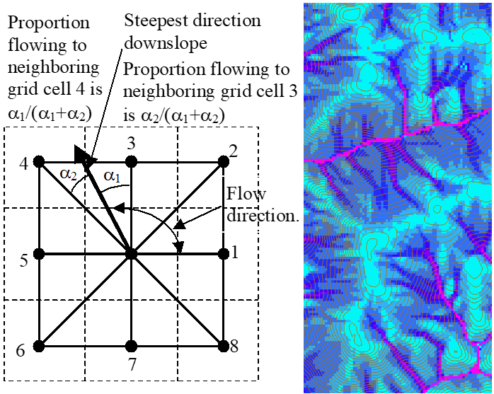
Calculates a grid of specific catchment area which is the contributing area per unit contour length using the multiple flow direction D-infinity approach. D-infinity flow direction is defined as steepest downward slope on planar triangular facets on a block centered grid. The contribution at each grid cell is taken as the grid cell length (or when the optional weight grid input is used, from the weight grid). The contributing area of each grid cell is then taken as its own contribution plus the contribution from upslope neighbors that have some fraction draining to it according to the D-infinity flow model. The flow from each cell either all drains to one neighbor, if the angle falls along a cardinal (0, pi/2, pi, 3pi/2) or ordinal (pi/4, 3pi/4, 5pi/4, 7pi/4) direction, or is on an angle falling between the direct angle to two adjacent neighbors. In the latter case the flow is proportioned between these two neighbor cells according to how close the flow direction angle is to the direct angle to those cells.
Using the grid cell size as the contribution at each grid cell assumes that grid cell size is the effective contour length in the definition of specific catchment area and does not distinguish any difference in contour length dependent upon the flow direction. The resulting units of the specific catchment area are then length units the same as those of the grid cell size.
If the optional outlet point shapefile is used, only the outlet cells and the cells upslope (by the D-infinity flow model) of them are in the domain to be evaluated.
By default Dinfinity specific catchment area is evaluated using checks for edge contamination. This is defined as the possibility that a contributing area value may be underestimated due to grid cells outside of the domain not being counted. This occurs when drainage is inwards from the boundaries or areas with "no data" values for elevation. The algorithm recognizes this and reports "no data" for the contributing area. It is common to see streaks of "no data" values extending inwards from boundaries along flow paths that enter the domain at a boundary. This is the desired effect and indicates that contributing area for these grid cells is unknown due to it being dependent on terrain outside of the domain of data available. Edge contamination checking may be turned off in cases where you know it is not an issue or want to ignore these problems, if for example, the DEM has been clipped along a watershed outline.