Quoted from: https://blog.utwente.nl/lisem/about/
openLISEM is a spatial hydrological model that simulates runoff, sediment dynamics and shallow floods in rural and urban catchments. It is an event based model, that can be used for catchments from 1 ha to several 100 km2. The model is designed to simulate the effects of detailed land use changes or conservation measures during heavy rainstorms. It is a model designed to be used in disaster risk management, not for long term estimates.
LISEM (the LImburg Soil Erosion Model) has been created to simulate the spatial effects of detailed soil and water conservation measures. These can be for instance on-field change of tillage direction, mulching, grass strips and minimum tillage, but also catchment based placement of storage buffers and sediment traps. Changes in soil structure by crusting and compaction can be taken into account.
Recent aditions are:
- Shallow floods based on the st Venant equation (with the University of Orleans)
- Specify urban environments (UN-HABITAT project, Kampala Integrated Flood Management project)
- Code to route substabnces such as pesticides (with Laboratoire de Solides et Fluide, Marie Curie University, Strasbourg)
- Tile drain systems (Bioforsk Norway)
- Water repelency effects, for instance after forest fires (Alterra, Wageningen)
The latest full manual of OpenLISEM is available on sourceforge and here: OpenLISEM Draft Documentation
OpenLISEM is a raster model that simulates the surface water and sediment balance for every gridcell. It is event based and has great spatial and temporal detail. The model is designed to simulate the effects of detailed land use changes or conservation measures on runoff, flooding and erosion during heavy rainstorms. It is a model designed to be used in disaster risk management, not for long term estimates.
The event based nature has two major a implications:
- The model does not simulate ‘slower’ processes such as evapotranspiration, groundwater flow or changes in vegetation because of crop growth, and that means you have to be careful about the initialize values you use in the model (for instance soil moisture).
- The model can handle any size catchment (the largest is several hundred km2 so far), but the grid cell size has to be smaller than 1 ha inorder for certain process assumptions to be correct. Large areas also need correct input data such as spatially varying rainfall. openLISEM will run with practically any dataset you throw at it, but that is not a guarantee for good results.
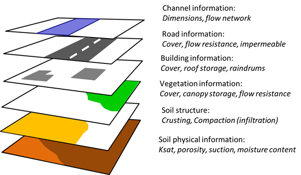
Emphasis is put on detail: characteristic about the model is the capacity to handle sub-gridcell surface properties. A gridcell can contain a bare soil, crusted/compacted soil, vegetated surface, a road, a house and a channel. These surface characteristics are supplied in separate layers as fractions: the base layer is formed by the soil surface with its hydrological charactristics and the user supplies aditional maps that trigger additional hydrological processes in the model. For instance the presense of a vegetation will result in interception on a part of the gridcell, presence of a house in interception and a partly impermeable surface, a road will have no infiltration and erosion but can have sedimentation etc.

In the flow chart below you see the basic structure of openLISEM: most of the water and sediment balance processes are calculated for the gridcell itself (1D). Spatial processes are runoff and channel flow (kinematic wave) and shallow flooding from the channel system (St Venant equations).

For more detail, see the full documentation