UrbanSim

UrbanSim is a simulation system for supporting planning and analysis of urban development, incorporating the interactions between land use, transportation, the economy, and the environment.

Urbanland usetransportationeconomyenvironment

Contributor(s)

Initial contribute: 2019-07-20

Authorship

:  
View
Is authorship not correct? Feed back

Classification(s)

Application-focused categoriesHuman-perspectiveDevelopment activities

Detailed Description

English {{currentDetailLanguage}} English

Quoted from: https://urbansim.com/urbansim

UrbanSim is a simulation system for supporting planning and analysis of urban development, incorporating the interactions between land use, transportation, the economy, and the environment. It is designed for use by Metropolitan Planning Organizations (MPOs), cities, counties, non-governmental organizations, real estate professionals, planners, researchers and students interested in exploring the effects of infrastructure and development constraints as well as other policies on community outcomes such as motorized and non-motorized accessibility, housing affordability, greenhouse gas emissions, and the protection of open space and environmentally sensitive habitats. UrbanSim is essentially a computational representation of metropolitan real estate markets interacting with transport markets, modeling the choices made by households, businesses, and real estate developers, and how these are influenced by governmental policies and investments.


UrbanSim simulates real estate markets by representing the choices of individual households and businesses (or jobs) making location choices. Locations and buildings can be represented at full detail, meaning individual buildings and individual parcels, or can be aggregated into building types and census blocks or zones to represent locations. These differences in geographic representation are the basis for three template versions of UrbanSim that are described in more detail below.

Regardless of which geographic representation is used, the model structure is similar. Households and businesses (jobs) move and make location choices as the regional economy grows, and real estate developers add housing and nonresidential buildings in response to changes in demand, and subject to local development constraints. Price and rent models predict the pricing outcomes in the real estate market, and adjust to reconcile shifts in demand and supply. A simplified flowchart illustrates this process below.


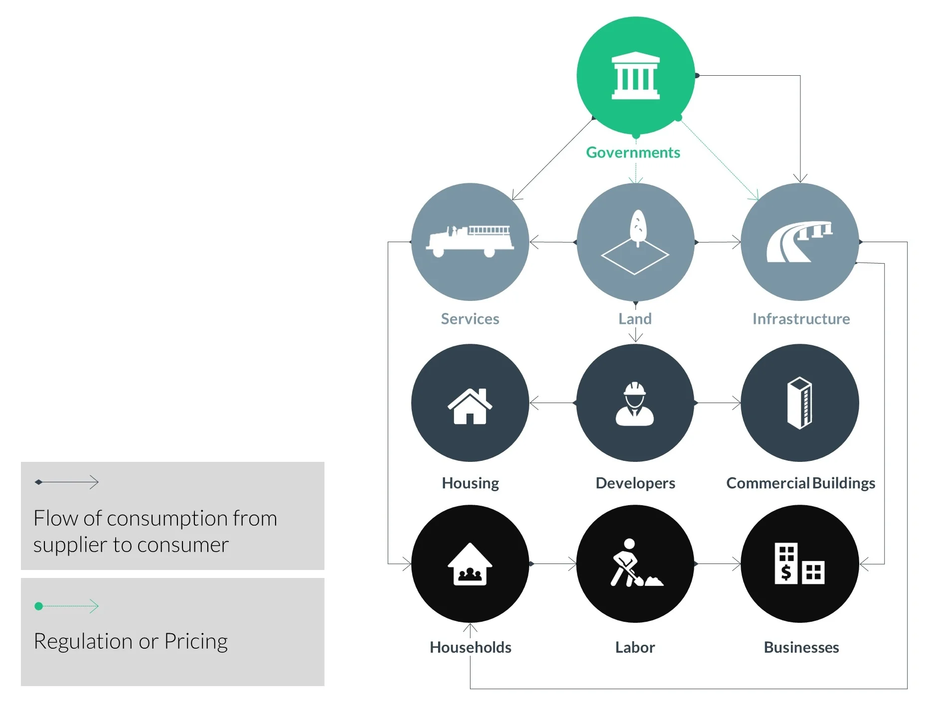
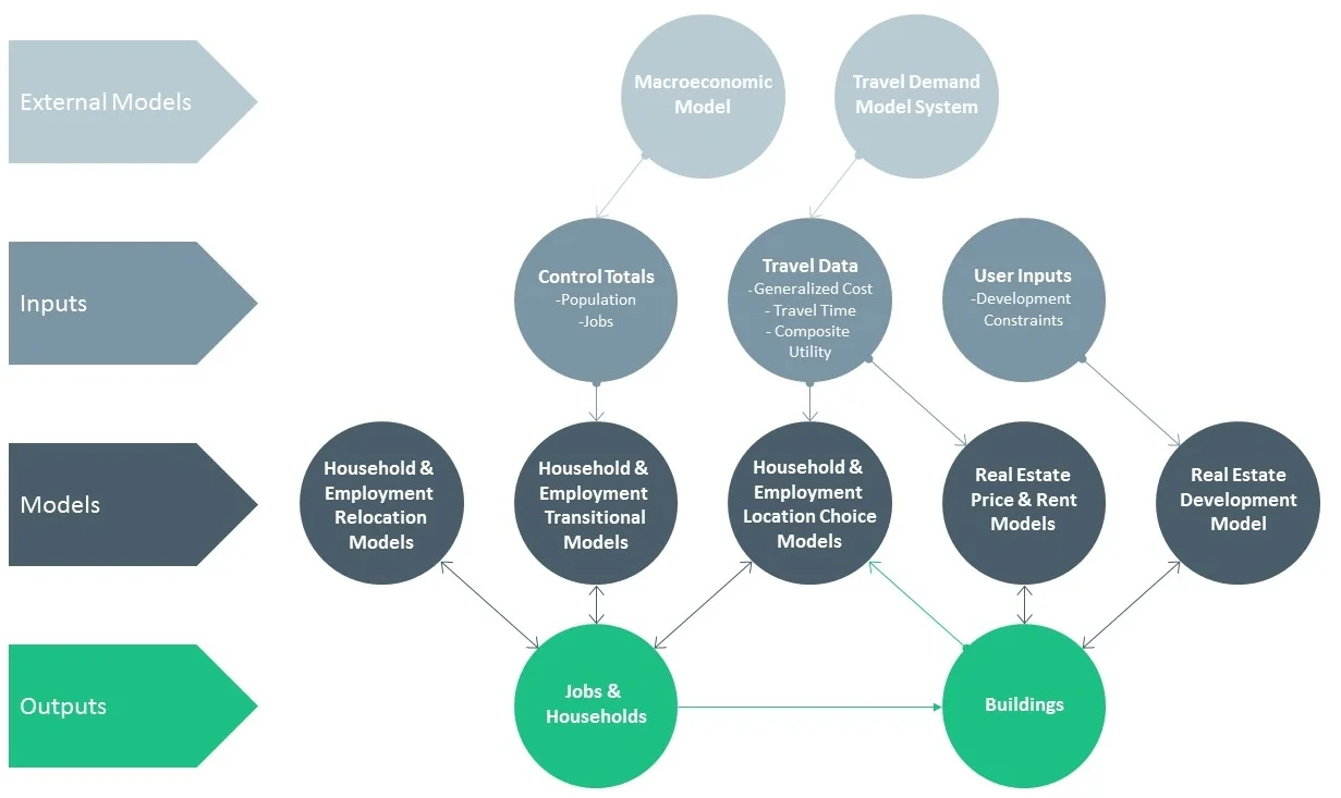
UrbanSim models are built using local data for each metropolitan area, and the parameters for each model are estimated using advanced statistical methods to ensure that the model actually reflects local conditions. In no case are models applied to a region using data or coefficients from another region. Finally, we provide tools to automatically search for the best-fitting model specifications, and to calibrate the models to observed data at a more aggregate level than the UrbanSim model predictions. For the census block models for the United States, we have already done all of these processes and the models are ready for use. For metropolitan areas anywhere in the world, we have options to implement UrbanSim models at a parcel level or a zone level. UrbanCanvas Modeler provides a web-based platform that provides additional tools to make it straightforward for new users to simply upload their data, and have our platform build and calibrate their UrbanSim models, preparing them for use in simulating policy scenarios.

Once the models are built and calibrated, they are ready to be used to evaluate alternative transportation plans and land use plans. Transportation plans are encoded in travel networks and need to be modeled by the user's own transport models as of now. Skims of the travel model network with congested travel times zone to zone, or generalized cost or composite utilities (logsums from the mode choice model, typically) can be used to inform UrbanSim about changes in the transportation system in different simulation years. Land use scenario inputs can come from comprehensive plans of local jurisdictions, or more generalized representations of development capacity. In UrbanCanvas Modeler, we provide easy to use visual interfaces to upload and edit inputs to UrbanSim scenarios. Once scenarios have been created, we provide the cloud infrastructure to simultaneously simulate as many scenarios as a user wishes.

As simulations are being run, UrbanCanvas Modeler provides feedback on progress. UrbanSim simulations run annually, over a simulation period specified by the user. Commonly the simulation period for long-range planning is 30 years. Smaller regions run typically in less than 30 seconds per year, while larger regions of 3-5 million population may take 2-4 minutes per year to simulate.

Once simulations are completed, users have access to a large number of indicators that can be created to better understand the results, at different levels of geography, and to evaluate the scenario from a policy perspective. In UrbanCanvas Modeler, users can visualize the indicators as 2D or 3D maps, charts, and tables. All in a web browser. 

模型元数据

{{htmlJSON.HowtoCite}}

UrbanSim group (2019). UrbanSim , Model Item, OpenGMS, https://geomodeling.njnu.edu.cn/modelItem/7ac28696-8dd3-49c8-86c1-c9e644fc2c99
{{htmlJSON.Copy}}

Contributor(s)

Initial contribute : 2019-07-20

{{htmlJSON.CoContributor}}

Authorship

:  
View
Is authorship not correct? Feed back

QR Code

×

{{curRelation.overview}}
{{curRelation.author.join('; ')}}
{{curRelation.journal}}


{{htmlJSON.RelatedItems}}

{{htmlJSON.LinkResourceFromRepositoryOrCreate}}{{htmlJSON.create}}.

Drop the file here, orclick to upload.
Select From My Space
+ add

{{htmlJSON.authorshipSubmitted}}

Cancel Submit
{{htmlJSON.Cancel}} {{htmlJSON.Submit}}
{{htmlJSON.Localizations}} + {{htmlJSON.Add}}
{{ item.label }} {{ item.value }}
{{htmlJSON.ModelName}}:
{{htmlJSON.Cancel}} {{htmlJSON.Submit}}
名称 别名 {{tag}} +
系列名 版本号 目的 修改内容 创建/修改日期 作者
摘要 详细描述
{{tag}} + 添加关键字
* 时间参考系
* 空间参考系类型 * 空间参考系名称

起始日期 终止日期 进展 开发者
* 是否开源 * 访问方式 * 使用方式 开源协议 * 传输方式 * 获取地址 * 发布日期 * 发布者


编号 目的 修改内容 创建/修改日期 作者


时间分辨率 时间尺度 时间步长 时间范围 空间维度 格网类型 空间分辨率 空间尺度 空间范围
{{tag}} +
* 类型
图例


* 名称 * 描述
示例描述 * 名称 * 类型 * 值/链接 上传


{{htmlJSON.Cancel}} {{htmlJSON.Submit}}
Title Author Date Journal Volume(Issue) Pages Links Doi Operation
{{htmlJSON.Cancel}} {{htmlJSON.Submit}}
{{htmlJSON.Add}} {{htmlJSON.Cancel}}

{{articleUploading.title}}

Authors:  {{articleUploading.authors[0]}}, {{articleUploading.authors[1]}}, {{articleUploading.authors[2]}}, et al.

Journal:   {{articleUploading.journal}}

Date:   {{articleUploading.date}}

Page range:   {{articleUploading.pageRange}}

Link:   {{articleUploading.link}}

DOI:   {{articleUploading.doi}}

Yes, this is it Cancel

The article {{articleUploading.title}} has been uploaded yet.

OK
{{htmlJSON.Cancel}} {{htmlJSON.Confirm}}
0jM1xPcELXqE