mHM (Mesoscale Hydrologic Model)

The mHM is a spatially distributed, grid-based mesoscale hydrologic model that accounts for the following main hydrologic processes: canopy interception, snow accumulation and melt, root zone soil moisture and evapotranspiration, infiltration, surface and subsurface runoff, percolation, baseflow and flood routing.

spatially distributedgrid-basedmesoscalehydrologic

Contributor(s)

Initial contribute: 2019-12-29

Authorship

:  
View
Is authorship not correct? Feed back

Classification(s)

Application-focused categoriesNatural-perspectiveLand regions

Detailed Description

English {{currentDetailLanguage}} English

Quoted from: https://www.ufz.de/index.php?en=40114 

The mesoscale hydrologic model (mHM) developed by our group is a spatially explicit distributed hydrologic model that uses grid cells as a primary hydrologic unit, and accounts for the following processes: canopy interception, snow accumulation and melting, soil moisture dynamics, infiltration and surface runoff, evapotranspiration, subsurface storage and discharge generation, deep percolation and baseflow and discharge attenuation and flood routing.

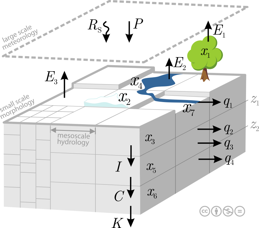
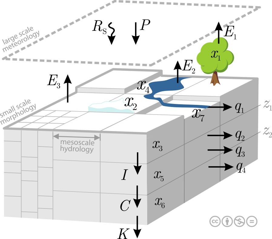
Schematic Representation of the Mesoscale Hydrologic Model
Fig. 1: Schematic of resolution levels, data, processes and states in mHM.

The model is driven by hourly or daily meteorological forcings (e.g., precipitation, temperature), and it utilizes observable basin physical characteristics (e.g., soil textural, vegetation, and geological properties) to infer the spatial variability of the required parameters.

The main feature of mHM is the approach to estimate parameters at the target resolution based on high resolution physiographic land surface descriptors (e.g., DEM, slope, aspect, root depth based on land cover class or plant functional types, LAI, soil texture, geological formation type) . The technique was proposed in Samaniego et al WRR 2010 and is called multiscale parameter regionalization (MPR). The MPR technique is crucial to reach flux-matching across scales and to derive seamless parameter fields (Samaniego et al HESS 2017).

模型元数据

{{htmlJSON.HowtoCite}}

mHM team (2019). mHM (Mesoscale Hydrologic Model), Model Item, OpenGMS, https://geomodeling.njnu.edu.cn/modelItem/7cb9aff4-9b9d-4de4-a71e-b5d035293ede
{{htmlJSON.Copy}}

Contributor(s)

Initial contribute : 2019-12-29

{{htmlJSON.CoContributor}}

Authorship

:  
View
Is authorship not correct? Feed back

QR Code

×

{{curRelation.overview}}
{{curRelation.author.join('; ')}}
{{curRelation.journal}}


{{htmlJSON.RelatedItems}}

{{htmlJSON.LinkResourceFromRepositoryOrCreate}}{{htmlJSON.create}}.

Drop the file here, orclick to upload.
Select From My Space
+ add

{{htmlJSON.authorshipSubmitted}}

Cancel Submit
{{htmlJSON.Cancel}} {{htmlJSON.Submit}}
{{htmlJSON.Localizations}} + {{htmlJSON.Add}}
{{ item.label }} {{ item.value }}
{{htmlJSON.ModelName}}:
{{htmlJSON.Cancel}} {{htmlJSON.Submit}}
名称 别名 {{tag}} +
系列名 版本号 目的 修改内容 创建/修改日期 作者
摘要 详细描述
{{tag}} + 添加关键字
* 时间参考系
* 空间参考系类型 * 空间参考系名称

起始日期 终止日期 进展 开发者
* 是否开源 * 访问方式 * 使用方式 开源协议 * 传输方式 * 获取地址 * 发布日期 * 发布者


编号 目的 修改内容 创建/修改日期 作者


时间分辨率 时间尺度 时间步长 时间范围 空间维度 格网类型 空间分辨率 空间尺度 空间范围
{{tag}} +
* 类型
图例


* 名称 * 描述
示例描述 * 名称 * 类型 * 值/链接 上传


{{htmlJSON.Cancel}} {{htmlJSON.Submit}}
Title Author Date Journal Volume(Issue) Pages Links Doi Operation
{{htmlJSON.Cancel}} {{htmlJSON.Submit}}
{{htmlJSON.Add}} {{htmlJSON.Cancel}}

{{articleUploading.title}}

Authors:  {{articleUploading.authors[0]}}, {{articleUploading.authors[1]}}, {{articleUploading.authors[2]}}, et al.

Journal:   {{articleUploading.journal}}

Date:   {{articleUploading.date}}

Page range:   {{articleUploading.pageRange}}

Link:   {{articleUploading.link}}

DOI:   {{articleUploading.doi}}

Yes, this is it Cancel

The article {{articleUploading.title}} has been uploaded yet.

OK
{{htmlJSON.Cancel}} {{htmlJSON.Confirm}}
2jVbIShjfXEy