Quoted from: DOI: 10.1007/s00267-002-2630-x Verburg, P.H., Soepboer, W., Veldkamp, A., Limpiada, R., Espaldon, V. and Mastura, S.S., 2002. Modeling the spatial dynamics of regional land use: the CLUE-S model. Environmental management, 30(3), pp.391-405.
The model is sub-divided into two distinct modules, namely a non-spatial demand module and a spatially explicit allocation procedure (Figure 2). The non-spatial module calculates the area change for all land-use types at the aggregate level. Within the second part of the model these demands are translated into land-use changes at different locations within the study region using a raster-based system.
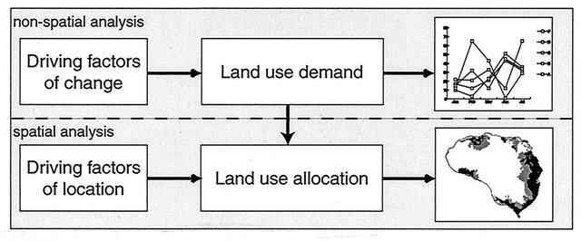
For the land-use demand module, different alternative model specifications are possible, ranging from simple trend extrapolations to complex economic models. The choice for a specific model is very much dependent on the nature of the most important land-use conversions taking place within the study area and the scenarios that need to be considered. Therefore, the demand calculations will differ between applications and scenarios and need to be decided by the user for the specific situation. The results from the demand module need to specify, on a yearly basis, the area covered by the different land-use types, which is a direct input for the allocation module. The rest of this paper focuses on the procedure to allocate these demands to land-use conversions at specific locations within the study area.
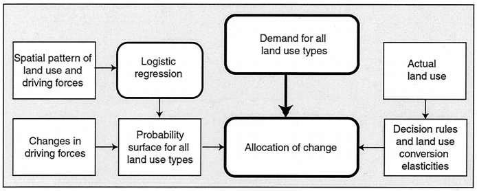
The allocation is based upon a combination of empirical, spatial analysis, and dynamic modelling. Figure 3 gives an overview of the procedure. The empirical analysis unravels the relations between the spatial distribution of land use and a series of factors that are drivers and constraints of land use. The results of this empirical analysis are used within the model when simulating the competition between land-use types for a specific location. In addition, a set of decision rules is specified by the user to restrict the conversions that can take place based on the actual land-use pattern. The different components of the procedure are now discussed in more detail.


