Quoted from: https://github.com/geotopmodel/geotop
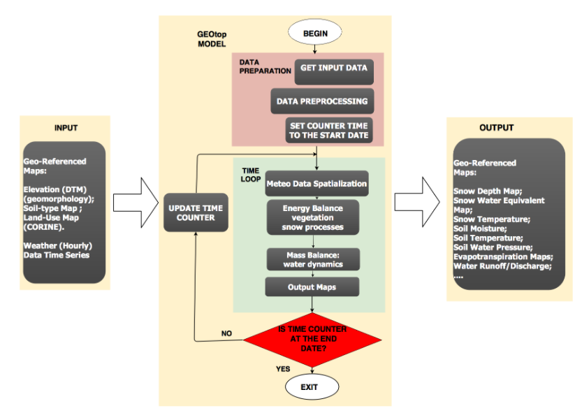
GEOtop is a distributed model of the mass and energy balance of the hydrological cycle, which is applicable to simulations in continuum in small catchments. GEOtop deals with the effects of topography on the interaction between energy balance and hydrological cycle with peculiar solutions.
GEOtop is distributed under the GNU General Public License version 3. A copy of the license text can be found in the COPYING file.
You can find more informations about GEOtop on the following website
www.geotop.org
where the model is briefly described and links to papers and other useful websites have been collected.
Installation
If you want to build GEOtop (master branch v.2.1) from sources in your own machine:
see here: https://github.com/geotopmodel/geotop/blob/master/doc/Install.rst
If you prefer to install GEOtop via Docker to avoid manual installation of packages:
see here: https://hub.docker.com/r/omslab/geotop
and here: https://github.com/geotopmodel/docker
Documentation
An old version of the manual (currently under revision) can be found here:
in the doc directory there is further documentation.
Documentation on former versions of the code can be found here:
http://eprints.biblio.unitn.it/551/
Useful material on GEOtop and his hystorical development can be found also on the R.Rigon blog:
http://abouthydrology.blogspot.com/
GEOtop development branches
Currently (December 2019) there are several development branches in this repostory. Most used branches are the followings:
The main **master** branch contains the 2.1 version. It is written in c++ and it has the possibility to use the the **MeteoIO** library to spatialize input meteorological variables.
This version is successfully used for operational snow mapping in the **MySnowMaps** app. However, this branch is not fully stable when the model is used with full 3D water and energy budget settings.
The **se27xx** branch contains the code 2.0 version which has been used for the publication Endrizzi et al. (2014), with some minor bug fixing. It is the most stable GEOtop version and the current benchmark for the development versions. To install this version see https://github.com/geotopmodel/geotop/blob/se27xx/README.rst
The new `v3.0 GEOtop development branch v3.0 (beta), written in C++, can be found in the git repo https://github.com/geotopmodel/geotop/tree/v3.0 at . You can find the compiling, running and testing instructions at https://github.com/geotopmodel/geotop/blob/v3.0/readme.md
The 3.0 version starts from version se27xx, already validated and published in the Endrizzi et al. 2014 paper. It performs exactly as the se27xx, but it has some improvements in terms of:
- usage of object-oriented approach
- development of new data structures
- ease of compiling and running
- modularity and flexibility
- increase in testing coverage.
However, it still lacks of the integration with the MeteoIO library and other features implemented in the current 2.1 version (master branch https://github.com/geotopmodel/geotop). In the next months we plan to move toward stable 3.0 version, together with a publication. We as developer would like to have some feedbacks from you! Bugs and suggestions can be addressed in the google groups or using pull requests. Further test cases to validate the model are also welcome.
Report bugs/suggestion/issues
Please use the github issues facility.
We have the following mailing lists:
GEOtopDev for developers and advanced users: https://groups.google.com/forum/#!forum/geotopdev
GEOtopUsers for regular users: https://groups.google.com/forum/#!forum/geotopusers
External utilities and pre-post processing scripts
During the years, several scripts and external softwares have been developed for preprocess GEOtop inputs, postprocess and visualize results. Some utilites can be found here:
There are R scripts (https://github.com/ecor/geotopbricks) for I/O and GEOtop results visualization. They work for versions 2.0 and 2.1. Mainly developed by Emanuele Cordano. There is also a stable version published on CRAN as R package (https://cran.r-project.org/package=geotopbricks/).
The R package Topo Sub (https://github.com/EURAC-Ecohydro/TopoSUB) allows to produce spatially-distributed GEOtop output maps from a limited number of 1D single column simulations using a clustering approach (neglecting 3D water interactions). It has been developed by Joel Fiddes (Fiddes and Gruber, 2012, https://doi.org/10.5194/gmd-5-1245-2012) and structured as R package by Johannes Brenner.
There are Matlab scripts (https://github.com/EURAC-Ecohydro/GEOmatlab) for I/O and GEOtop results visualization. They work for version 1.25, most of them also for version 2.0. Mainly developed by Giacomo Bertoldi and collaborators.
GEOtop can be embedded in the GEOframe modelling system (https://github.com/GEOframeOMSProjects). Mainly developed by Riccardo Rigon, Giuseppe Formetta and collaborators. For more info see: Formetta et al. (2016a)
External models extensions
Thsere are several GEOtop model extensions, to deal with additional physical processes.
GEOtop model particle swarm optimization with R
The plugin R package geotopOtim2 (https://github.com/EURAC-Ecohydro/geotopOptim2) allows the automatic calibration and sensitivity analysis of the GEOtop 2.x hydrological model, based on the "Particle Swarm Optimisation" approach and the LHOAT "Latin-Hypercube One-factor-At-a-Time" approach. It has been mainly developed by Emanuele Cordano, Samuel Senoner, Giacomo Bertoldi. A paper is in preparation.
GEOtop model optimization with PEST
It has been developed an interface for **PEST** software package for parameter estimation and uncertainty analysis. An example of the GEOtop-PEST interface for inverse modelling in the Rott catchment can be found at: https://doi.pangaea.de/10.1594/PANGAEA.892921. Full details can be found in the paper Soltani et al. (2019)
In general, PEST requires the following input files for automatic parameter estimation and inverse modelling: (i) Template files, to identify the model parameters; (ii) Instruction files, to identify the model outputs; and (iii) Control file, which supplies PEST with the names of all template and instruction files, the names of model input and output files, initial parameter values, measurement values and weights, etc. (Doherty, 2010).
The PEST software (Doherty, 2002) together with over 100-utility-programs such as SENSAN and GENLINPRED used herein are freely available at http://www.pesthomepage.org/Downloads.php. For detailed and comprehensive information for combining a model of interest with PEST, it is referred to Sect. “3. The Model-PEST Interface” of the PEST manual, as described in Doherty (2002).
GEOtop model for shallow landslides triggering prediction.
GEOtop-SF has been one of the first fully distributed hydrolgical models applied for hallow landslides triggering prediction. A fundamental paper is Simoni et al. (2008), which is referred to the old 0.875 version of the model.
A more recent implementation of GEOtop for shallow landslides prectition can be found in Formetta et al. (2016b), where GEOtop is embedded in the GEOframe modelling system.
GEOtop model for soil erosion prediction.
GEOtop_SED is an extension of GEOtop for modelling sediment dynamics simulating the spatio-temporal dynamics of soil erosion , deposition. Documentation can be found in Zi et al. (2016)
The code of the GEOtop_sed model extension can be dowloaded from the repository: https://github.com/TanZiTT/GEOtopSed
GEOtop model for vegetation dynamic simulation.
GEOtop_DV is a Matlab extension of GEOtop for modelling grassland vegetation dynamics for 1D simulations. Documentation can be found in * Della Chiesa et al. (2014)
Operational GEOtop model applications
Snow depth mapping
The GEOtop model (v 2.1) is the scientific basis of the **MySnowMaps** service, which presents real time snow depth maps and prediction fot the alps, implemented by M. Dall´Amico the **MobyGis** company.
Water budget mapping
A preliminary application of the GEOtop model (v 3.0) for mapping the water budget of the Venosta (Italy) catchment in near real time on a weekly basis has implemented in the following web-gis: https://maps.civis.bz.it/ in the framework of the European Regional Development Fund (ERDF) project DPS4ESLAB.
References
When using the model, please cite and refer to the following papers describing the GEOtop model:
- Endrizzi, S., Gruber, S., Dall’Amico, M., Rigon, R., 2014. GEOtop 2.0: simulating the combined energy and water balance at and below the land surface accounting for soil freezing, snow cover and terrain effects. Geosci. Model Dev. 7, 2831–2857. https://doi.org/10.5194/gmd-7-2831-2014
- Rigon, R., Bertoldi, G., Over, T.M., 2006. GEOtop: A Distributed Hydrological Model with Coupled Water and Energy Budgets. J. Hydrometeorol. 7, 371–388. https://doi.org/10.1175/JHM497.1
Here is the full list of peer-reviewed publications using the GEOtop model (updated December 2019):
- Wani, J.M., Thayyen, R.J., Gruber, S., Ojha, C.S.P., Stumm, D., 2020. Single-year thermal regime and inferred permafrost occurrence in the upper Ganglass catchment of the cold-arid Himalaya, Ladakh, India. Sci. Total Environ. 703, 134631. https://doi.org/10.1016/j.scitotenv.2019.134631
- Zi, T., Kumar, M., Albertson, J., 2019. Intercomparing varied erosion, deposition and transport process representations for simulating sediment yield. Sci. Rep. 9, 1–13. https://doi.org/10.1038/s41598-019-48405-9
- Fiddes, J., Aalstad, K., Westermann, S., 2019. Hyper-resolution ensemble-based snow reanalysis in mountain regions using clustering. Hydrol. Earth Syst. Sci. 23, 4717–4736. https://doi.org/10.5194/hess-23-4717-2019
- Fullhart, A.T., Kelleners, T.J., Speckman, H.N., Beverly, D., Ewers, B.E., Frank, J.M., Massman, W.J., 2019. Measured and Modeled Above‐ and Below‐Canopy Turbulent Fluxes for a Snow‐Dominated Mountain Forest Using Geotop, Hydrological Processes. https://doi.org/10.1002/hyp.13487
- Soltani, M., Laux, P., Mauder, M., Kunstmann, H., 2019. Inverse distributed modelling of streamflow and turbulent fluxes: A sensitivity and uncertainty analysis coupled with automatic optimization. J. Hydrol. 571, 856–872. https://doi.org/10.1016/j.jhydrol.2019.02.033
- Formetta, G., Capparelli, G., 2019. Quantifying the three-dimensional effects of anisotropic soil horizons on hillslope hydrology and stability. J. Hydrol. 570, 329–342. https://doi.org/10.1016/j.jhydrol.2018.12.064
- Kiese, R., Fersch, B., Baessler, C., Brosy, C., Butterbach-Bahl, K., Chwala, C., Dannenmann, M., Fu, J., Gasche, R., Grote, R., Jahn, C., Klatt, J., Kunstmann, H., Mauder, M., Rödiger, T., Smiatek, G., Soltani, M., Steinbrecher, R., Völksch, I., Werhahn, J., Wolf, B., Zeeman, M., Schmid, H.P., 2018. The TERENO Pre-Alpine Observatory: Integrating Meteorological, Hydrological, and Biogeochemical Measurements and Modeling. Vadose Zo. J. 17, 0. https://doi.org/10.2136/vzj2018.03.0060
- Soltani, M., Laux, P., Mauder, M., Kunstmann, H., 2018. Spatiotemporal variability and empirical Copula-based dependence structure of modeled and observed coupled water and energy fluxes. Hydrol. Res. nh2018163. https://doi.org/10.2166/nh.2018.163
- Pullens, J.W.M., Sottocornola, M., Kiely, G., Gianelle, D., Rigon, R., 2018. Assessment of the water and energy budget in a peatland catchment of the Alps using the process based GEOtop hydrological model. J. Hydrol. 563, 195–210. https://doi.org/10.1016/j.jhydrol.2018.05.041
- Fullhart, A.T., Kelleners, T.J., Chandler, D.G., Mcnamara, J.P., Seyfried, M.S., 2018. Water Flow Modeling with Dry Bulk Density Optimization to Determine Hydraulic Properties in Mountain Soils. Soil Sci. Soc. Am. J. 82, 31–44. https://doi.org/10.2136/sssaj2017.06.0196
- Kollet, S., Sulis, M., Maxwell, R.M.R.M., Paniconi, C., Putti, M., Bertoldi, G., Coon, E.T.E.T., Cordano, E., Endrizzi, S., Kikinzon, E., Mouche, E., Mügler, C., Park, Y.-J.Y.-J., Refsgaard, J.C.J.C., Stisen, S., Sudicky, E., 2017. The integrated hydrologicmodel intercomparison project, IH-MIP2: A second set of benchmark results to diagnose integrated hydrology and feedbacks. Water Resour. Res. 53, 867–890. https://doi.org/10.1002/2014WR015716
- Engel, M., Notarnicola, C., Endrizzi, S., Bertoldi, G., 2017. Snow model sensitivity analysis to understand spatial and temporal snow dynamics in a high-elevation catchment. Hydrol. Process. 31, 4151–4168. https://doi.org/10.1002/hyp.11314
- Mauder, M., Genzel, S., Fu, J., Kiese, R., Soltani, M., Steinbrecher, R., Zeeman, M., Banerjee, T., De Roo, F., Kunstmann, H., 2017. Evaluation of energy balance closure adjustment methods by independent evapotranspiration estimates from lysimeters and hydrological simulations. Hydrol. Process. https://doi.org/10.1002/hyp.11397
- Formetta, G., Capparelli, G., David, O., Green, T.R., Rigon, R., 2016. Integration of a Three-Dimensional Process-Based Hydrological Model into the Object Modeling System. Water 8, 1–15. https://doi.org/10.3390/w8010012
- Hingerl, L., Kunstmann, H., Wagner, S., Mauder, M., Bliefernicht, J., Rigon, R., 2016. Spatio-temporal variability of water and energy fluxes - a case study for a mesoscale catchment in pre-alpine environment. Hydrol. Process. 30, 3804–3823. https://doi.org/10.1002/hyp.10893
- Zi, T., Kumar, M., Kiely, G., Lewis, C., Albertson, J., 2016. Simulating the spatio-temporal dynamics of soil erosion , deposition , and yield using a coupled sediment dynamics and 3D distributed hydrologic model. Environ. Model. Softw. 83, 310–325. https://doi.org/10.1016/j.envsoft.2016.06.004
- Formetta, G., Simoni, S., Godt, J.W., Lu, N., Rigon, R., 2016. Geomorphological control on variably saturated hillslope hydrology and slope instability. Water Resour. Res. 52, 4590–4607. https://doi.org/10.1002/2015WR017626
- Greifeneder, F., Notarnicola, C., Bertoldi, G., Brenner, J., Wagner, W., 2015. A novel approach to improve spatial detail in modeled soil moisture through the integration of remote sensing data, in: Geoscience and Remote Sensing Symposium (IGARSS), 2015 IEEE International. pp. 1988–1991. https://doi.org/10.1109/IGARSS.2015.7326187
- Fiddes, J., Endrizzi, S., Gruber, S., 2015. Large-area land surface simulations in heterogeneous terrain driven by global data sets : application to mountain permafrost. Cryosph. 9, 411–426. https://doi.org/10.5194/tc-9-411-2015
- Eccel, E., Cordano, E., Zottele, F., 2015. A project for climatologic mapping of soil water content in Trentino. Ital. J. Agrometeorol. 1, 5–20.
- Bertoldi, G., Della Chiesa, S., Notarnicola, C., Pasolli, L., Niedrist, G., Tappeiner, U., Della, S., Notarnicola, C., Pasolli, L., Niedrist, G., Tappeiner, U., 2014. Estimation of soil moisture patterns in mountain grasslands by means of SAR RADARSAT2 images and hydrological modeling. J. Hydrol. 516, 245–257. https://doi.org/10.1016/j.jhydrol.2014.02.018
- Endrizzi, S., Gruber, S., Dall’Amico, M., Rigon, R., 2014. GEOtop 2.0: simulating the combined energy and water balance at and below the land surface accounting for soil freezing, snow cover and terrain effects. Geosci. Model Dev. 7, 2831–2857. https://doi.org/10.5194/gmd-7-2831-2014
- Della Chiesa, S., Bertoldi, G., Niedrist, G., Obojes, N., Endrizzi, S., Albertson, J.D., Wohlfahrt, G., Hörtnagl, L., Tappeiner, U., 2014. Modelling changes in grassland hydrological cycling along an elevational gradient in the Alps. Ecohydrology n/a--n/a. https://doi.org/10.1002/eco.1471
- Cordano, E., Rigon, R., 2013. A mass-conservative method for the integration of the two-dimensional groundwater (Boussinesq) equation. Water Resour. Res. 49, 1058–1078. https://doi.org/10.1002/wrcr.20072
- Lewis, C., Albertson, J., Zi, T., Xu, X., Kiely, G., 2013. How does afforestation affect the hydrology of a blanket peatland? A modelling study. Hydrol. Process. 27, 3577–3588. https://doi.org/10.1002/hyp.9486
- Gubler, S., Endrizzi, S., Gruber, S., Purves, R.S., 2013. Sensitivities and uncertainties of modeled ground temperatures in mountain environments. Geosci. Model Dev. 6, 1319–1336. https://doi.org/10.5194/gmd-6-1319-2013
- Fiddes, J., Gruber, S., 2012. TopoSUB: a tool for efficient large area numerical modelling in complex topography at sub-grid scales. Geosci. Model Dev. 5, 1245–1257. https://doi.org/10.5194/gmd-5-1245-2012
- Dall’Amico, M., Endrizzi, S., Gruber, S., Rigon, R., 2011. A robust and energy-conserving model of freezing variably-saturated soil. Cryosph. 5, 469–484. https://doi.org/10.5194/tc-5-469-2011
- Bertoldi, G., Notarnicola, C., Leitinger, G., Endrizzi, S., Della Chiesa, S., Zebisch, M., Tappeiner, U., Della Chiesa, S., Tappeiner, U., 2010. Topographical and ecohydrological controls on land surface temperature in an Alpine catchment. Ecohydrology 3, 189–204. https://doi.org/10.1002/eco.129
- Endrizzi, S., Marsh, P., 2010. Observations and modeling of turbulent fluxes during melt at the shrub-tundra transition zone 1: point scale variations. Hydrol. Res. 41, 471–490.
- Gebremichael, M., Rigon, R., Bertoldi, G., Over, T.M.M., 2009. On the scaling characteristics of observed and simulated spatial soil moisture fields. Nonlin. Process. Geophys. 16, 141–150. https://doi.org/10.5194/npg-16-141-2009
- Simoni, S., Zanotti, F., Bertoldi, G., Rigon, R., 2008. Modelling the probability of occurrence of shallow landslides and channelized debris flows using GEOtop-FS. Hydrol. Process. doi: 10.10, 532–545. https://doi.org/10.1002/hyp.6886
- Bertoldi, G., Rigon, R., Over, T.M.M., 2006. Impact of Watershed Geomorphic Characteristics on the Energy and Water Budgets. J. Hydrometeorol. 7, 389–403. https://doi.org/10.1175/JHM500.1
- Rigon, R., Bertoldi, G., Over, T.M.M., 2006. GEOtop: A Distributed Hydrological Model with Coupled Water and Energy Budgets. J. Hydrometeorol. 7, 371–388. https://doi.org/10.1175/JHM497.1
- Zanotti, F., Endrizzi, S., Bertoldi, G., Rigon, R., 2004. The GEOtop snow module. Hydrol. Proc. 18, 3667–3679. DOI:10.1002/hyp.5794. https://doi.org/10.1002/hyp.5794