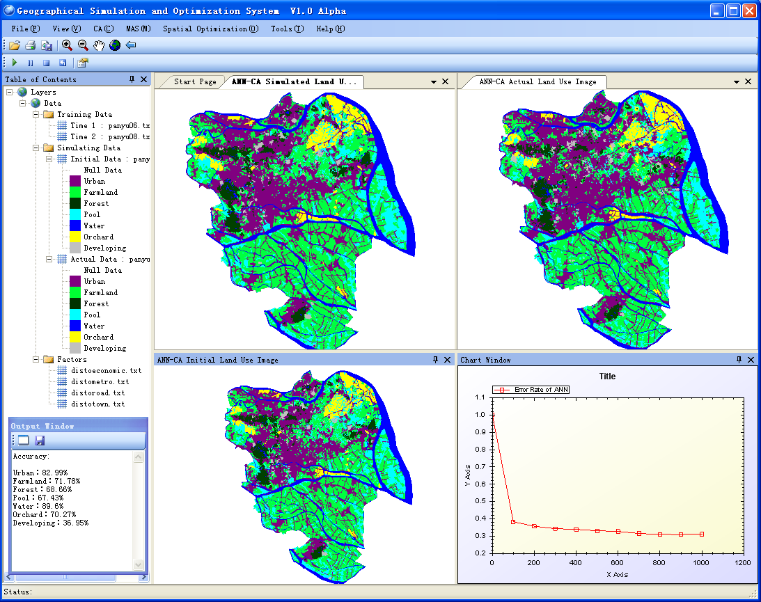
GeoSOS (Geographical Simulation and Optimization System)

GeoSOS integrates cellular automata (CA), agent-based models (ABMs), and swarm intelligence models (SIMs) for solving geographical processes simulation and complex spatial optimization problems, such as land use change, urban growth, natural protection areas zoning and facilities sitting.

cellular automataland usespatial optimizationurban growth

Contributor(s)

Initial contribute: 2018-06-21

Authorship

:  
East China Normal University
:  
lixia@geo.ecnu.edu.cn
:  
View
Is authorship not correct? Feed back

Classification(s)

Application-focused categoriesHuman-perspectiveDevelopment activities

Detailed Description

English {{currentDetailLanguage}} English

  (1) Introduction 

   Artificial neural networks-cellular automata(ANN-CA) model, a nonlinear tool ,has been applied successfully in LUC(Simulation of land use change) simulation. In the model, CA performs as bottom-up simulation framework.

   ANN is used as data mining tools to mine the transition rules of LUC for CA; it means that ANN is used to understand the underlying patterns in LUC data. ANN has the advantage of being able to observe relationships in data by emulating the brain’s ability to sort patterns through the interconnected systems of many neurons. ANN is an appropriate global parametric model for simulating LUC whereas various spatial drivers simulate land transformation in a non-linear way. Also, ANN is very effective in handling incorrect and inferior data, and capturing non-linear, complex features in modelling processes; therefore, it has been generally accepted that they are capable of achieving results with superior accuracy in modelling.

 (2) Schematic and description

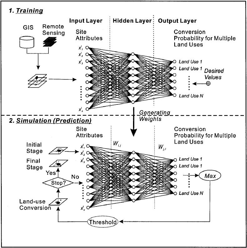
     The Training phase of ANN-CA : The artificial neural network was trained with sampled data to obtain the network weight value. The input data are: various factors that affect land use change, statistical values of land use types in the neighborhood window, and current land use types. The output value is the probability value of various land use types.

     The Simulation phase of ANN-CA: The type to be converted is obtained through the artificial neural network, and it is judged whether the current grid can be converted. The termination condition is reached and the simulation process ends. During the simulation, the probability values of all land types are obtained through ANN. The maximum value corresponds to the type of land use to be converted, and then the threshold comparison is used to determine whether it can be converted.
 

  (3) Calculation formula

       (4) Instruction
       
      ANN-CA is suitable for conducting many types of land-use conversions.
      ANN-CA uses the strategy of defining the number of urban land grid conversions as the termination conditions for the simulation. That is, the amount of conversion at the termination of the simulation = the number of grids of urban land at the time of simulation termination - the number of grids of urban land at the initial simulation time.
 
       (5) Example result


模型元数据

{{htmlJSON.HowtoCite}}

Xia Li (2018). GeoSOS (Geographical Simulation and Optimization System), Model Item, OpenGMS, https://geomodeling.njnu.edu.cn/modelItem/d801fad5-9e76-4c55-a082-b8dc364b8308
{{htmlJSON.Copy}}

History

Last modifier
Xia Li
Last modify time
2022-08-03
Modify times
View History

Contributor(s)

Initial contribute : 2018-06-21

{{htmlJSON.CoContributor}}

Authorship

:  
East China Normal University
:  
lixia@geo.ecnu.edu.cn
:  
View
Is authorship not correct? Feed back

History

Last modifier
Xia Li
Last modify time
2022-08-03
Modify times
View History

QR Code

×

{{curRelation.overview}}
{{curRelation.author.join('; ')}}
{{curRelation.journal}}


{{htmlJSON.RelatedItems}}

{{htmlJSON.LinkResourceFromRepositoryOrCreate}}{{htmlJSON.create}}.

Drop the file here, orclick to upload.
Select From My Space
+ add

{{htmlJSON.authorshipSubmitted}}

Cancel Submit
{{htmlJSON.Cancel}} {{htmlJSON.Submit}}
{{htmlJSON.Localizations}} + {{htmlJSON.Add}}
{{ item.label }} {{ item.value }}
{{htmlJSON.ModelName}}:
{{htmlJSON.Cancel}} {{htmlJSON.Submit}}
名称 别名 {{tag}} +
系列名 版本号 目的 修改内容 创建/修改日期 作者
摘要 详细描述
{{tag}} + 添加关键字
* 时间参考系
* 空间参考系类型 * 空间参考系名称

起始日期 终止日期 进展 开发者
* 是否开源 * 访问方式 * 使用方式 开源协议 * 传输方式 * 获取地址 * 发布日期 * 发布者


编号 目的 修改内容 创建/修改日期 作者


时间分辨率 时间尺度 时间步长 时间范围 空间维度 格网类型 空间分辨率 空间尺度 空间范围
{{tag}} +
* 类型
图例


* 名称 * 描述
示例描述 * 名称 * 类型 * 值/链接 上传


{{htmlJSON.Cancel}} {{htmlJSON.Submit}}
Title Author Date Journal Volume(Issue) Pages Links Doi Operation
{{htmlJSON.Cancel}} {{htmlJSON.Submit}}
{{htmlJSON.Add}} {{htmlJSON.Cancel}}

{{articleUploading.title}}

Authors:  {{articleUploading.authors[0]}}, {{articleUploading.authors[1]}}, {{articleUploading.authors[2]}}, et al.

Journal:   {{articleUploading.journal}}

Date:   {{articleUploading.date}}

Page range:   {{articleUploading.pageRange}}

Link:   {{articleUploading.link}}

DOI:   {{articleUploading.doi}}

Yes, this is it Cancel

The article {{articleUploading.title}} has been uploaded yet.

OK
{{htmlJSON.Cancel}} {{htmlJSON.Confirm}}
pCp0R1o8LiE_