InVEST Sediment Delivery Ratio Model

The objective of the InVEST Sediment Delivery Ratio (SDR) model is to map overland sediment generation and delivery to the stream.

Sedimentgeneration and delivery

Alias

InVEST SDR

Contributor(s)

Initial contribute: 2019-07-14

Authorship

:  
Stanford University
:  
View
Is authorship not correct? Feed back

Classification(s)

Application-focused categoriesNatural-perspectiveLand regions

Detailed Description

English {{currentDetailLanguage}} English

Quoted from: https://storage.googleapis.com/releases.naturalcapitalproject.org/invest-userguide/latest/sdr.html

Summary

The objective of the InVEST Sediment Delivery Ratio (SDR) model is to map overland sediment generation and delivery to the stream. In the context of global change, such information can be used to study the service of sediment retention in a catchment. This is of particular interest for reservoir management and instream water quality, both of which may be economically valued.

Introduction

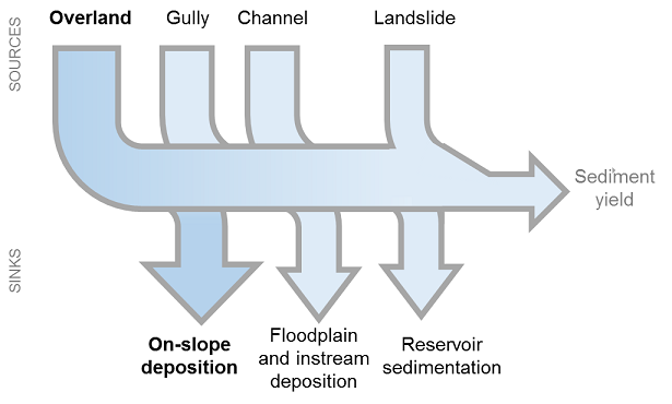
Erosion and overland sediment retention are natural processes that govern the sediment concentration in streams. Sediment dynamics at the catchment scale are mainly determined by climate (in particular rain intensity), soil properties, topography, and vegetation; and anthropogenic factors such as agricultural activities or dam construction and operation. Main sediment sources include overland erosion (soil particles detached and transported by rain and overland flow), gullies (channels that concentrate flow), bank erosion, and mass erosion (or landslides; see Merrit 2003 for a review). Sinks include on-slope, floodplain or instream deposition, and reservoir retention, as summarized in Figure 1. Conversion of land use and changes in land management practices may dramatically modify the amount of sediment running off a catchment. The magnitude of this effect is primarily governed by: i) the main sediment sources (land use change will have a smaller effect in catchments where sediments are not primarily coming from overland flow); and ii) the spatial distribution of sediment sources and sinks (for example, land use change will have a smaller effect if the sediment sources are buffered by vegetation).

Increases in sediment yield are observed in many places in the world, dramatically affecting water quality and reservoir management (UNESCO 2009). The sediment retention service provided by natural landscapes is of great interest to water managers. Understanding where the sediments are produced and delivered allow managers to design improved strategies for reducing sediment loads. Changes in sediment load can have impacts on downstream irrigation, water treatment, recreation and reservoir performance.

Outputs from the sediment model include the sediment load delivered to the stream at an annual time scale, as well as the amount of sediment eroded in the catchment and retained by vegetation and topographic features. Note that SDR only creates biophysical results. For valuation of the sediment retention service, appropriate valuation approaches will be highly dependent on the particular application and context, and need to be implemented independently of InVEST.


_images/sediment_budget.png

Figure 1: General catchment sediment budget. The relative size of the arrows changes depending on the environment. The InVEST model focuses on the overland sources and sinks, and does not include the others.

The Model

Sediment Delivery

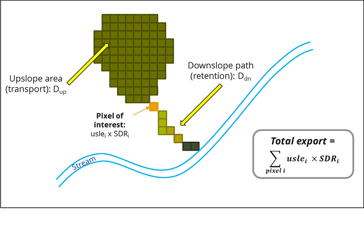
The sediment delivery module is a spatially-explicit model working at the spatial resolution of the input digital elevation model (DEM) raster. For each pixel, the model first computes the amount of annual soil loss from that pixel, then computes the sediment delivery ratio (SDR), which is the proportion of soil loss actually reaching the stream. Once sediment reaches the stream, we assume that it ends up at the catchment outlet, thus no in-stream processes are modeled. This approach was proposed by Borselli et al. (2008) and has received increasing interest in recent years (Cavalli et al., 2013; López-vicente et al., 2013; Sougnez et al., 2011). See the User Guide section Differences between the InVEST SDR model and the original approach developed by Borselli et al. (2008) for further discussion.

模型元数据

{{htmlJSON.HowtoCite}}

Natural Capital Project (2019). InVEST Sediment Delivery Ratio Model , Model Item, OpenGMS, https://geomodeling.njnu.edu.cn/modelItem/4a8f7ae3-c735-4222-94ee-01f4703c6943
{{htmlJSON.Copy}}

Contributor(s)

Initial contribute : 2019-07-14

{{htmlJSON.CoContributor}}

Authorship

:  
Stanford University
:  
View
Is authorship not correct? Feed back

QR Code

×

{{curRelation.overview}}
{{curRelation.author.join('; ')}}
{{curRelation.journal}}


{{htmlJSON.RelatedItems}}

{{htmlJSON.LinkResourceFromRepositoryOrCreate}}{{htmlJSON.create}}.

Drop the file here, orclick to upload.
Select From My Space
+ add

{{htmlJSON.authorshipSubmitted}}

Cancel Submit
{{htmlJSON.Cancel}} {{htmlJSON.Submit}}
{{htmlJSON.Localizations}} + {{htmlJSON.Add}}
{{ item.label }} {{ item.value }}
{{htmlJSON.ModelName}}:
{{htmlJSON.Cancel}} {{htmlJSON.Submit}}
名称 别名 {{tag}} +
系列名 版本号 目的 修改内容 创建/修改日期 作者
摘要 详细描述
{{tag}} + 添加关键字
* 时间参考系
* 空间参考系类型 * 空间参考系名称

起始日期 终止日期 进展 开发者
* 是否开源 * 访问方式 * 使用方式 开源协议 * 传输方式 * 获取地址 * 发布日期 * 发布者


编号 目的 修改内容 创建/修改日期 作者


时间分辨率 时间尺度 时间步长 时间范围 空间维度 格网类型 空间分辨率 空间尺度 空间范围
{{tag}} +
* 类型
图例


* 名称 * 描述
示例描述 * 名称 * 类型 * 值/链接 上传


{{htmlJSON.Cancel}} {{htmlJSON.Submit}}
Title Author Date Journal Volume(Issue) Pages Links Doi Operation
{{htmlJSON.Cancel}} {{htmlJSON.Submit}}
{{htmlJSON.Add}} {{htmlJSON.Cancel}}

{{articleUploading.title}}

Authors:  {{articleUploading.authors[0]}}, {{articleUploading.authors[1]}}, {{articleUploading.authors[2]}}, et al.

Journal:   {{articleUploading.journal}}

Date:   {{articleUploading.date}}

Page range:   {{articleUploading.pageRange}}

Link:   {{articleUploading.link}}

DOI:   {{articleUploading.doi}}

Yes, this is it Cancel

The article {{articleUploading.title}} has been uploaded yet.

OK
{{htmlJSON.Cancel}} {{htmlJSON.Confirm}}
WZWRsXO46mdj