高精度曲面建模 HASM (High Accuracy Surface Modeling)

为了解决空间曲面建模的误差、多尺度、非线性、运算速度和大数据处理等理论问题,岳天祥研究员团队通过曲面论、系统论和优化控制论以及现代计算机技术的有机结合,创建了集成外蕴量(例如卫星遥感信息)与内蕴量(例如地面观测信息)的高精度曲面建模(HASM)方法,进而提炼形成了地球表层系统建模基本定理和生态环境曲面建模基本定理及其关于空间插值、尺度转换、数据融合和模型-数据同化的推论和算法。

HASMaccuracyinterpolationdata fusion

Alias

HASM

Contributor(s)

Initial contribute: 2022-07-11

Authorship

:  
中国科学院地理科学与资源研究所
:  
yue@lreis.ac.cn
:  
View
Is authorship not correct? Feed back

Classification(s)

Application-focused categoriesHuman-perspectiveEconomic activities
Application-focused categoriesIntegrated-perspectiveGlobal scale
Application-focused categoriesIntegrated-perspectiveRegional scale
Method-focused categoriesData-perspectiveGeoinformation analysis
Method-focused categoriesData-perspectiveGeostatistical analysis

Detailed Description

English {{currentDetailLanguage}} English

1. 模型用途:基于系统论、曲面论和优化控制论有机结合的高精度曲面建模方法(HASM)是近几年发展起来的一种新的可用于空间插值和预测的方法(Yue, 2011),其克服了地理信息系统中的经典曲面建模方法的误差、多尺度、非线性、运算速度和大数据处理等理论和实践问题。数值试验和实例验证都表明,HASM模拟精度高于经典的空间建模方法。

2. 发展历程:HASM的发展过程可区分为6个阶段:

a) 1986-2001年,我们将曲线论基本定理引入生态环境曲面建模,将生态环境曲面作为其剖面的集合来处理, 这个方法后来发展成为为地表变化探测模型。

b2001-2007年,将曲面论基本定理引入了生态环境曲面建模,建立了由第一类基本量和第二类基本量合成的高精度曲面建模方程。第一类基本量是内蕴量,用于“在地球表面上”量测计算地球表面的几何属性;第二类基本量是外蕴量,被用于量测计算“在地球表面之外”观测的地球表面的局部变化,从而解决了半个世纪以来困扰曲面建模的误差问题和多尺度问题。

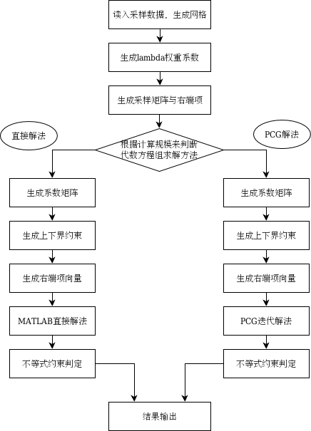
c2007-2011年,为了提升HASM运算速度和对海量数据的处理能力,建立了HASM多重网格法(HASM-MG)、自适应法(HASM-AM)、修正的共轭梯度法(HASM-PCG)和平差算法(HASM-AC),初步解决了曲面建模速度慢、内存需求大等问题。

d2011-2016年,通过对高精度曲面建模理论发展和应用研究的提炼总结,形成了地球表层系统建模基本定理(FTESM)及其关于空间插值、升尺度、降尺度、数据融合和模型-数据同化的推论。

e2016-2020年,在联合国IPBES概念体系下,将地球表层系统及其生态环境要素按自然系统、自然系统对人类贡献和自然系统变化驱动力进行分类,并将自然系统曲面、自然系统变化驱动力曲面和自然系统对人类贡献曲面统称为生态环境曲面。将地球表层系统建模基本定理转型为生态环境曲面建模基本定理(FTEEM)。

f2020年以来,聚焦量子计算、智能计算、四维建模和模型耦合等问题研究。

模型元数据

{{htmlJSON.HowtoCite}}

岳天祥 (2022). 高精度曲面建模 HASM (High Accuracy Surface Modeling), Model Item, OpenGMS, https://geomodeling.njnu.edu.cn/modelItem/7756b02e-893f-459c-89b9-7bc8c176ef11
{{htmlJSON.Copy}}

History

Last modifier
Tianxiang Yue
Last modify time
2022-07-27
Modify times
10  View History

Contributor(s)

Initial contribute : 2022-07-11

{{htmlJSON.CoContributor}}

Authorship

:  
中国科学院地理科学与资源研究所
:  
yue@lreis.ac.cn
:  
View
Is authorship not correct? Feed back

History

Last modifier
Tianxiang Yue
Last modify time
2022-07-27
Modify times
10  View History

QR Code

×

{{curRelation.overview}}
{{curRelation.author.join('; ')}}
{{curRelation.journal}}


{{htmlJSON.RelatedItems}}

{{htmlJSON.LinkResourceFromRepositoryOrCreate}}{{htmlJSON.create}}.

Drop the file here, orclick to upload.
Select From My Space
+ add

{{htmlJSON.authorshipSubmitted}}

Cancel Submit
{{htmlJSON.Cancel}} {{htmlJSON.Submit}}
{{htmlJSON.Localizations}} + {{htmlJSON.Add}}
{{ item.label }} {{ item.value }}
{{htmlJSON.ModelName}}:
{{htmlJSON.Cancel}} {{htmlJSON.Submit}}
名称 别名 {{tag}} +
系列名 版本号 目的 修改内容 创建/修改日期 作者
摘要 详细描述
{{tag}} + 添加关键字
* 时间参考系
* 空间参考系类型 * 空间参考系名称

起始日期 终止日期 进展 开发者
* 是否开源 * 访问方式 * 使用方式 开源协议 * 传输方式 * 获取地址 * 发布日期 * 发布者


编号 目的 修改内容 创建/修改日期 作者


时间分辨率 时间尺度 时间步长 时间范围 空间维度 格网类型 空间分辨率 空间尺度 空间范围
{{tag}} +
* 类型
图例


* 名称 * 描述
示例描述 * 名称 * 类型 * 值/链接 上传


{{htmlJSON.Cancel}} {{htmlJSON.Submit}}
Title Author Date Journal Volume(Issue) Pages Links Doi Operation
{{htmlJSON.Cancel}} {{htmlJSON.Submit}}
{{htmlJSON.Add}} {{htmlJSON.Cancel}}

{{articleUploading.title}}

Authors:  {{articleUploading.authors[0]}}, {{articleUploading.authors[1]}}, {{articleUploading.authors[2]}}, et al.

Journal:   {{articleUploading.journal}}

Date:   {{articleUploading.date}}

Page range:   {{articleUploading.pageRange}}

Link:   {{articleUploading.link}}

DOI:   {{articleUploading.doi}}

Yes, this is it Cancel

The article {{articleUploading.title}} has been uploaded yet.

OK
{{htmlJSON.Cancel}} {{htmlJSON.Confirm}}
M2lgFhrNKaeI