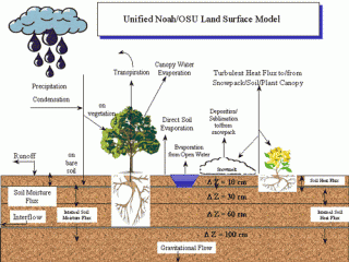
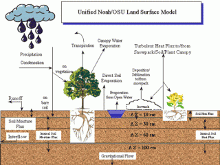
N: National Centers for Environmental Prediction (NCEP)
O: Oregon State University (Dept of Atmospheric Sciences)
A: Air Force (both AFWA and AFRL - formerly AFGL, PL)
H: Hydrology Lab - NWS (formerly Office of Hydrology - OH)
Below are quoted from: Niu, Guo‐Yue, Zong‐Liang Yang, Kenneth E. Mitchell, Fei Chen, Michael B. Ek, Michael Barlage, Anil Kumar et al. "The community Noah land surface model with multiparameterization options (Noah‐MP): 1. Model description and evaluation with local‐scale measurements." Journal of Geophysical Research: Atmospheres 116, no. D12 (2011). https://doi.org/10.1029/2010JD015139
The Noah LSM has a long history of development through multiinstitutional cooperation [Mahrt and Ek, 1984; Mahrt and Pan, 1984; Pan and Mahrt, 1987; Chen et al., 1996; Schaake et al., 1996; Chen et al., 1997; Koren et al., 1999; Ek et al., 2003] and has been widely used by the National Centers for Environmental Prediction (NCEP) in operational weather and climate predictions, by the Weather Research Forecast (WRF) model community, and by the Air Force Weather Agency. The development efforts have improved the model performance in both offline [Mitchell et al., 2004; Chen et al., 2007] and coupled modes [Ek et al., 2003].
Noah version 3.0 (V3) has a combined surface layer of vegetation and soil surface, over which surface energy fluxes are computed. Such a model structure impedes its further development as a process‐based dynamic leaf model, because it cannot explicitly compute photosynthetically active radiation (PAR), canopy temperature, and related energy, water, and carbon fluxes. Noah has a bulk layer of snow and soil. For a thick snowpack, such a layer structure tends to underestimate the ground heat flux because of the combined thickness of snowpack and half of the top‐layer soil, leaving too much energy at the snow surface and being thus too prone to snowmelt. Additionally, percolation, retention, and refreezing of melt liquid water cannot be readily represented in such a layer structure. Noah has a total soil depth of two meters and uses gravitational free drainage at the model bottom as the lower boundary condition of soil moisture. Drained water from the 2 m soil bottom should accumulate in its underlying soil or aquifer during wet seasons when recharge rate exceeds discharge rate and, driven by capillary forces, be able to be drawn back to the 2 m soil column in dry seasons. Noah's shallow soil column is not able to capture the critical zone (down to 5 m) to which the surface energy budgets are most sensitive [Kollet and Maxwell, 2008]; immediate removal of the drained water (due to the free drainage scheme) in Noah may result in too short memories of antecedent weather events or climate anomalies. The impeding effect of frozen soil on infiltration and further effects on river discharge is evidently weaker [e.g., Shanley and Chalmers, 1999; Lindström et al., 2002] than that represented in most LSMs. The frozen soil in Noah is too impervious under most vegetation and climate conditions, resulting in too much surface runoff in spring or early summer and, hence, less infiltration of snowmelt water into soil.
Below are quoted from: https://ral.ucar.edu/solutions/products/unified-noah-lsm
RAL scientists work to understand, through theoretical and observational studies, the complex biophysical, hydrological, and bio-geochemical interactions between the land-surface and the atmosphere at micro- and mesoscales. The ultimate goal is to integrate such knowledge into numerical mesoscale weather prediction and regional climate models to improve prediction of the impacts of land-surface processes on regional weather, climate, and hydrology. Land surface modeling efforts were funded in FY06 by NSF, the Air Force Weather Agency (AFWA), NOAA, NASA, and DTRA.
UNIFIED NOAH LSM REFERENCES

Unified WRF-Noah LSM
- Chen, F., K. Mitchell, J. Schaake, Y. Xue, H. Pan, V. Koren, Y. Duan, M. Ek, and A. Betts, 1996: Modeling of land-surface evaporation by four schemes and comparison with FIFE observations. J. Geophys. Res., 101, 7251-7268.
- Chen, F., Z. Janjic, K. Mitchell, 1997: Impact of atmospheric surface layer parameterization in the new land-surface scheme of the NCEP Mesoscale Eta numerical model. Bound.-Layer Meteor., 185, 391-421.
- Chen, F. and J.Dudhia, 2001: Coupling an Advanced Land Surface-Hydrology Model with the Penn State-NCAR MM5 Modeling System. Part I: Model Implementation and Sensitivity. Mon. Wea. Rev., 129, 569-585.
- Ek, M. B., K. E. Mitchell, Y. Lin, E. Rogers, P. Grummann, V. Koren, G. Gayno, and J. D. Tarpley, 2003: Implementation of Noah land surface model advances in the National Centers for Environmental Prediction operational Mesoscale Eta Model.J. Geophys. Res., 108, 8851, doi:10.1029/2002JD003296.
- Koren, V., J. Schaake, K. Mitchell, Q.-Y. Duan, and F. Chen, 1999: A parameterization of snowpack and frozen ground intended for NCEP weather and climate models. J. Geophys. Res., 104, 19569-19585.
VERSION 3.4.1
- Noah LSM Version 3.4.1 code -- August 2012
COMPARISONS OF SUCCESSIVE CODE VERSIONS: RESULTS FROM THE SIMPLE DRIVER.


